Photo courtesy of Dave Schul
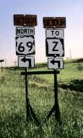
In Daviess County during May 1999, supplemental route Z was detoured along I-35 northbound between exits 72 and 78. All the Route Z signs were state primary route markers (i.e., state outlines) rather than secondary route markers (i.e., squares). Dave Schul observed at least ten such markers.
(Side note from Dave Schul: Exit 78 takes you to "New" Pattonsburg, a collection of new and old homes scattered around on new, suburban-size lots. Pattonsburg was moved after the town flooded in 1993, and vestiges of the old town have been incorporated in a very random manner in the new version. Two 75%-occupied strip malls facing each other across the new town's main street fill the role of a downtown for this very intriguing community.)