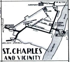
The inset map for St. Charles, from the official 1950 Missouri highway map. Missouri 94 still goes through St. Charles, but the role of By-Pass US 40 is now taken by Interstate 70. The route of Business Loop 70 within St. Charles is somewhat different from the By-Pass US 40 route shown in 1950. The bridge over the Missouri River, later the Highway 115 bridge, is now gone. St. Charles itself is quite a bit larger and is effectively a suburb of St. Louis.