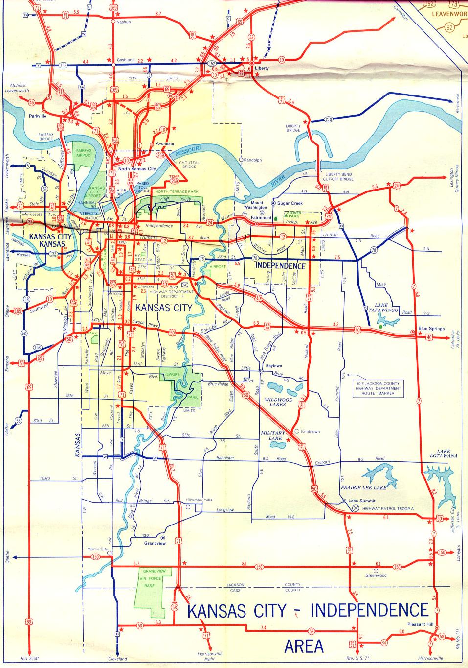
This is the inset map for Kansas City from the 1956 official state highway map.
Changes since 1956 to the routes shown on this map include:
- Missouri 10 now ends at Excelsior Springs (northeast of Liberty).
- Missouri 152 has moved onto a freeway that largely parallels the route shown here.
- Bypass US 71 has been replaced by Missouri 291 along its entire route.
- Alternate US 69 north of the Missouri River probably is now Interstate 35.
- Alternate US 169 north of the Missouri River is now US 169.
- North of the Missouri and Kansas rivers, US 169 has been removed from the US 69-US 169 concurrence.
- The dotted line between the US 69-US 169-Alternate US 169 intersection and Alternate US 69 probably is now Interstate 29.
- Missouri 210 has been extended westward all the way to North Kansas City.
- Missouri 269 now only exists on a short segment from what is shown here as Alternate US 69 (which is now probably Interstate 35) to just north of the Chouteau Bridge. The "TEMP" Missouri 269 shown here was eventually moved to the Chouteau Trafficway and even later was decommissioned.
- Alternate US 40 and Optional US 40 are decommissioned. Neither 31st Street or Linwood Boulevard currently carry a highway designation.
- Alternate US 71 is decommissioned. Neither Troost Avenue nor the Paseo currently carry a highway designation.
- In later years, US 71 was moved to Prospect Avenue (paralleling the Paseo on the east) and then moved the Watkins Drive freeway and parkway when it was built in the 1990s.
- US 50 along what is shown here as Blue Ridge Road was later renamed Blue Parkway and redesignated Missouri 350. US 50 within Kansas City is either decommissioned or is now US 56 (which did not exist until 1957).
- Missouri 12 now ends on the west at Interstate 435, which here would be approximately at the Kansas City line west of Independence. On the east, it ends west of downtown Independence at Spring Street. Also note that, by this time, the former 15th Street had been renamed Truman Road.
- Missouri 78 also ends on the west at Interstate 435. Its eastern endpoint is still at Missouri 7.
- Spur Missouri 58 by the Grandview Air Force Base (now the Kansas City International Freight Gateway) has been decommissioned.
- Also note the Jackson County route designations. They're still on the map, but in recent years, they haven't been signed.