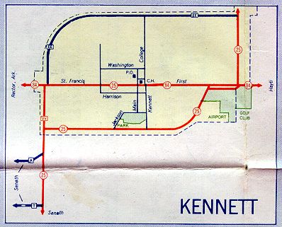
This is the inset map for Kennett from the 1957 official state highway map. The numbered routes shown on this map were Missouri 25 and Missouri 84 (both in red).
The concurrence shown for Missouri 25 and Missouri 84 in the center of Kennett may have been an error. In the 1958 official Missouri map, the Kennett inset does not show the concurrence.
Also note that a supplemental route, Route VV, is shown in red. Perhaps this reflected Route VV's role as a connector on the west side of Kennett between Missouri 25 and Missouri 84.