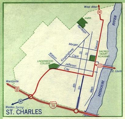
This is the inset map for St. Charles from the 1959 official state highway map. Interstate 70 makes its first appearance as a completed freeway on this map. This was one of the first Interstate highway segments to be built in the United States. The first span of the Blanchette Memorial Bridge is also shown on this map. It was built as part of the Interstate 70 project.
Three other numbered routes were shown on this map, Bypass US 40 (concurrent with Interstate 70), Missouri 115 (in red), and Missouri 94 (in red along Second Street in St. Charles and in dark blue southwest of Bypass US 40). Missouri 115 was extended from St. Louis County along the former route of Bypass US 40.