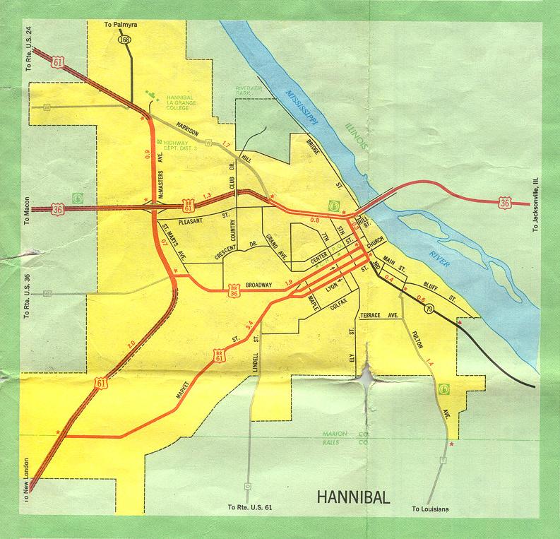
This is the inset map for Hannibal from the 1969 official state highway map. Indicating shifting fortunes over the latter part of the 20th century, the 2005-2006 official map does not have a dedicated inset for Hannibal. Even so, there have been several changes, all caused by the opening of the new Mark Twain Bridge in 2000:
- Interstate 72 has been extended from Illinois into Hannibal, ending at or near a new interchange with US 61.
- US 36 has been rerouted to be concurrent with Interstate 72 from US 61 eastward.
- The 1930s-era Mark Twain bridge has been replaced by a new Mark Twain bridge across the Mississippi River in the north part of the city. The new bridge opened to traffic on September 16, 2000. US 36 and Interstate 72 now are routed on the new bridge.
- The old Mark Twain bridge has been demolished.
- The old four-lane segment from Harrison Hill Road into downtown is now Missouri 79 and Business US 61. In other words, Missouri 79 has been extended from its previous endpoint at Mark Twain Avenue and 3rd northwestward to meet up with I-72/US 36 at Harrison Hill.
- Actually, strictly speaking, it's only Missouri 79 that was extended. Business US 61 ran along the same route when that route was US 36, before all the realignments in 2000. Business US 61's north and west endpoint was, and still is, at US 61 (McMaster Avenue).
- Field reports indicate that Route W along Haddon Hill Road was decommissioned.
Thanks to Brian Dowd, Phillip Christensen, David Hermann, and Adam Froehlig for their insights into the 2000 realignments of routes in Hannibal.