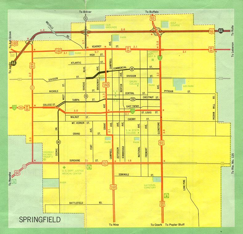
This is the inset map for Springfield from the 1969 official state highway map. Since 1969, changes have included:
- US 66 and Business US 66 were decommissioned.
- US 60 was moved to the James River Freeway, whose location would be shown on this map at its bottom edge.
- US 160 now runs along the West Bypass, shown on this map as Missouri 13 from Interstate 44 southward. US 160 joins US 60 at the James River Freeway.
- US 160 along Kearney Street is now Missouri 744.
- US 160 along Grant Avenue and Campbell Avenue was decommissioned.
- Missouri 88 was decommissioned.
- Missouri 13 now runs along the Kansas Expressway (shown on this inset as Kansas Street, largely hidden by the crease in the map), which has also been extended southward from Sunshine Street to the James River Freeway.
- US 65 was moved to a freeway paralleling the eastern city line of Springfield. As a consequence, the western endpoint of Route YY was moved to the new US 65.
- US 65 along Glenstone Avenue is now Business US 65 south of Chestnut Street.
- The Chestnut Expressway is an extension of Chestnut Street built to connect Glenstone and the new US 65. It is designated Business US 65.
- US 60 along Sunshine Street is now Missouri 413 from US 160 (Business US 66 and Missouri 13 on this map) to the Kansas Expressway (at the crease on the map, now Missouri 13).
- Missouri 266 was replaced in Springfield by Business Loop 44.
- Business Loop 44 along St. Louis Street was moved to Chestnut St. (now also Chestnut Expressway)