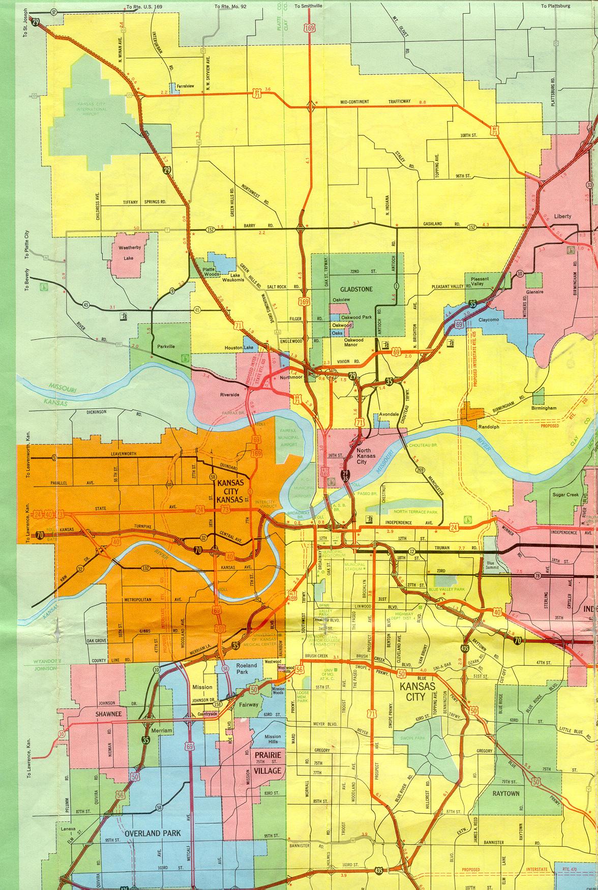
This is the inset map for Kansas City from the 1969 official state highway map. The sections for the eastern part of Jackson County are shown in another scan centered on Independence.
Changes since 1969 include:
- Proposed routes for Missouri 210, Interstate 435, Interstate 470, and Interstate 635 have all been built.
- The western and southern legs of the downtown freeway loop were built.
- Interstate 670 was built, connecting Interstate 70 in Kansas City, Kansas with the southwest corner of the freeway loop in Kansas City, Missouri.
- Alternate US 169 was decommissioned in Kansas City south of the Missouri River.
- North of the river, Alternate US 169 is now Missouri 9 from the "Y" intersection in North Kansas City south to the river.
- From that "Y" intersection to Interstate 35 near Vivion Road, Alternate US 169 is now Missouri 283.
- US 50 was rerouted to be concurrent along Interstate 435 and Interstate 470 from the Kansas line to the US 50 interchange in Lee's Summit near Unity Village.
- US 50 from Interstate 435 to the US 50/Interstate 470 interchange is now Missouri 350.
- US 50 from just east of Prospect Avenue (at Watkins Drive, see below) to Interstate 435 was decommissioned.
- The rest of US 50 in Missouri is now US 56.
- The Watkins Drive freeway/parkway is the new route of US 71. It runs from the southeast corner of the downtown freeway loop, across Brush Creek, and extends south and south-southeastward to the Interstate 435/470 interchange (the "Grandview Triangle"). On the 1969 map, this route is shown from 85th Street southward. It took many years for the freeway to be built north from 85th.
- US 71 along Prospect Avenue was decommissioned.
- Missouri 78 along 23rd Street from Van Brunt Boulevard to Interstate 435 in Kansas City has been decommissioned.
- Missouri 152 has been rerouted onto a freeway that mostly parallels Barry Road to the north.
- Missouri 1 was rerouted onto a new alignment from the Missouri 152 freeway south to the western most jog of Antioch Road in Gladstone. The route is also known as North Prospect Avenue.
- Missouri 10 in Liberty was decommissioned. Parts of this route are now Route H. See the section of this inset for Liberty for more details.
- Business US 71 from Vivion Road (US 69) in Kansas City, going through Riverside to Alternate US 169 in North Kansas City, is now Missouri 9.
- Business US 71 from Interstate 29 to Vivion Road (US 69) in Riverside is now Route AA.
- Bypass US 71 is now Missouri 291 (entire route). The section labeled here as the Mid-Continent Trafficway is now called Cookingham Drive, named after longtime city manager L.P. Cookingham.
- US 169 was rerouted in the mid-1990s as the new designation for the Broadway Extension. The Broadway Extension is shown but not marked on the 1969 map. It joins the US 169 freeway on the north, runs along the Municipal Airport on the airport's eastern border, and crosses the Missouri River on the Broadway Bridge. The Broadway Bridge has not been a toll bridge since 1991.
- Missouri 269 was decommissioned south from the Missouri 210 freeway (shown on this map as a proposed route).
- The Chouteau Bridge was replaced but the route fundamentally didn't change.
- Route W in Platte County was decommissioned.
There were also several changes in Kansas. Most notably, Rainbow Boulevard is now US 169 and Kansas 158 was decommissioned.
Also see sections of this inset for Independence, Lee's Summit, and Liberty for more details in eastern Jackson and Clay counties.