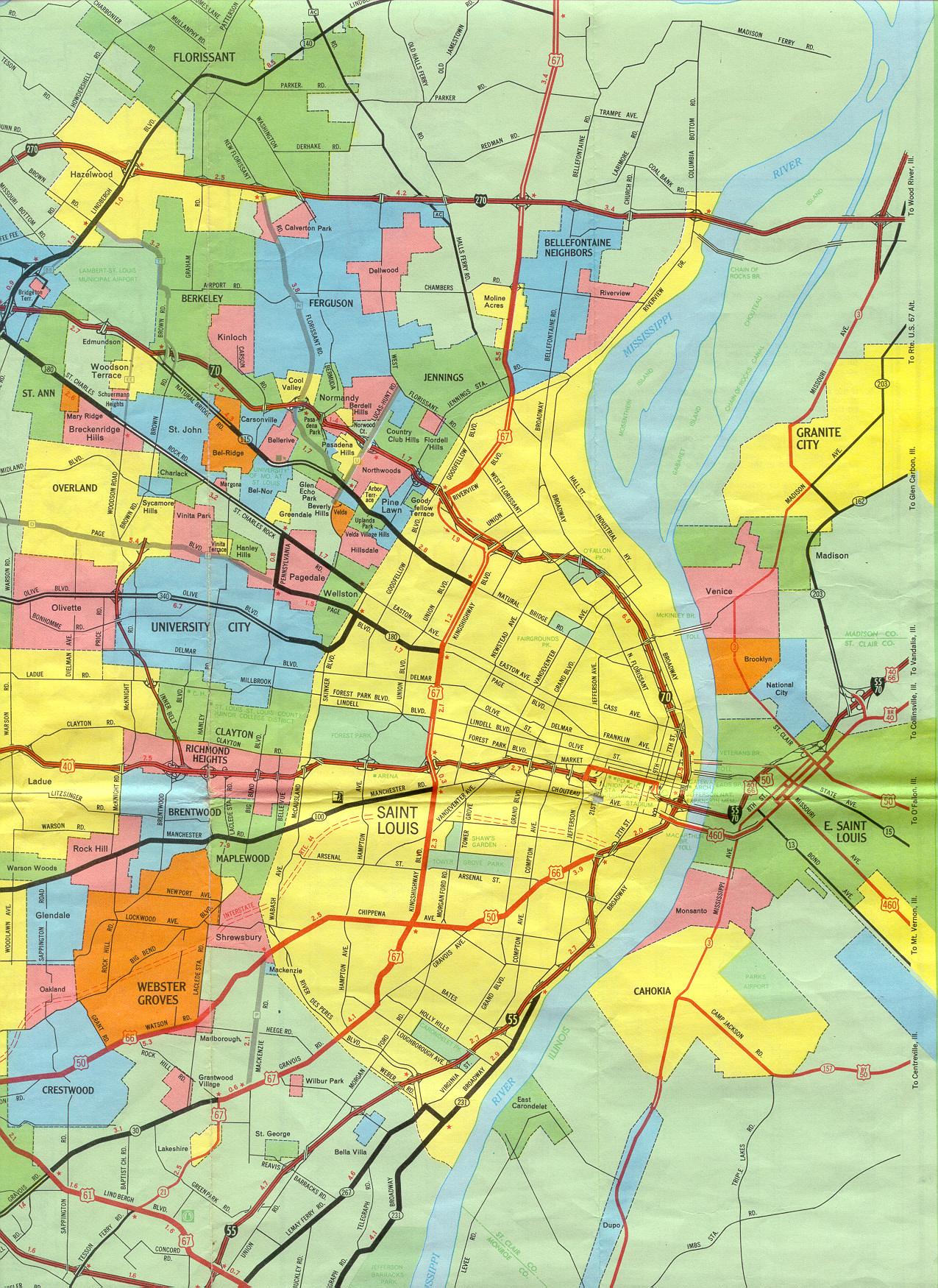
This is the inset map for St. Louis from the 1969 official state highway map. Changes since 1969 include:
- The Inner Belt was extended northward to Interstate 270. It is now designated as Interstate 170.
- Interstate 44, shown here as a proposed route, was built.
- The MacArthur Bridge was closed to vehicular traffic, meaning that US 460 no longer enters Missouri.
- US 40 is now also designated as Interstate 64. Almost no one in St. Louis calls it that.
- The section of US 40 just west of downtown St. Louis has been built as a two-level freeway.
- US 67 was moved from Riverview Blvd., Kingshighway, Gravois Ave., and Tesson Ferry Road to Lindbergh Blvd. This means that US 67 no longer enters the city of St. Louis.
- The section of former US 67 from Lindbergh to Interstate 70 in St. Louis (going through Bellefontaine Neighbors and Moline Acres) is now Missouri 367. At the St. Louis city line, Missouri 367 continues along Riverview Blvd. until reaching Interstate 70.
- Within the city of St. Louis, Hall Street and Riverview Drive are now Route H. They did not have a state designation in 1969.
- The whereabouts of the small city of Carsonville are a mystery. It apparently disincorporated at some time after 1969.
- Missouri 100 has been extended along Manchester Road past Kingshighway, reaching Chouteau Avenue and proceeding along Chouteau until ending at a point under Interstate 55.
- All the toll bridges across the Mississippi River either no longer charge tolls or are not in use.
- US 66 has been decommissioned.
- US 50 was rerouted onto Lindbergh Boulevard to Interstate 255 going into Illinois.
- Missouri 30 was extended northeastward on Gravois St. into the city of St. Louis, ending at Interstate 55.
- Chippewa Avenue in St. Louis and Watson Road in St. Louis County, formerly US 50 and US 66, are now Missouri 366.
- The Missouri 140 designation for Lindbergh Boulevard was replaced by US 67.
- The interchange at Brown Road and Interstate 70 has been replaced by the Interstate 70-Interstate 170 interchange.
- Missouri 180 now goes into the city of St. Louis on Martin Luther King Blvd. (shown on this map as Easton Avenue); the section of Missouri 180 along Pennsylvania Street in Pagedale is now Spur 180. Franklin Avenue in St. Louis has also been incorporated into Martin Luther King Blvd.
- At the far left edge of this excerpt, the interchange of Missouri 180 and Lindbergh is now a diamond interchange.
- The eastern endpoint of Missouri 340 is now at the St. Louis city line.
- Missouri 231 and 267 now have their northern endpoints at the St. Louis city line, though there is the possibility they may be returned to the state highway system.
Other notable changes, not shown on this map but shown on some of the maps listed below, include the redesignation of Interstate 244 as Interstate 270, and the extension of Page Boulevard into St. Charles County with the designation of Missouri 364.
Also see sections of this inset for Bridgeton, Florissant and Hazelwood (North County), South County, and West County for more details in areas not fully shown on this map.