Part Two
We headed back to the south after a couple of days, planning a stopover in Forster, in the Myall Lakes area. We stopped for lunch at a wildlife park in Port Macquarie. We didn't go into the town itself because of the aforementioned triathlon: many of the routes into Port Macquarie were closed for the event. At the wildlife park, we finally saw koalas. Earlier, at Coffs Harbour, people pointed us to koalas, but all we could see were little gray blobs high in eucalyptus ("gum") trees. We developed a theory that there really weren't koalas in Australia; it was just some blobs of gray matter strapped into trees, possibly lint from vacuum cleaners. Just kidding, of course, but koalas are not, shall we say, the most energetic of animals. They don't do much.
There had been severe flooding the previous night in Port Macquarie, which had also damaged the animal park, stranding some kangaroos on the wrong side of a creek for part of the day.
There's not much more to say about the roads, since we mostly backtracked on our way to Forster and thence south to Sydney the next day on our way to the Blue Mountains. There was another spectacular view of the Pacific Ocean, at Cape Hawke southeast of Forster, one of the places where Captain James Cook landed in 1770 during his voyage to explore the South Pacific.
It was back on the F3 freeway to its end, but this time, we took Highway 7, rather than Highway 1, in order to connect with the M7 Westlink motorway, a toll road through western Sydney. There are no toll booths on the Westlink; all payment is electronic. If you don't have an electronic tag, there's a local-rate number to call to report your license plate and to set up a short-term account. That was another instance where the mobile phone was extremely useful.
Europcar had thoughtfully included a Sydway street guide along with the rental car. This book is one of three covering major Australian cities. The others are the Melway for Melbourne, and Brisway for Brisbane. They're the Australian equivalent of a Thomas Brothers Guide, and you'll even see Sydway or Melway coordinates given in advertisements. The maps are detailed, and include this extremely helpful feature: they indicate traffic signals at intersections. Good move all the way around.
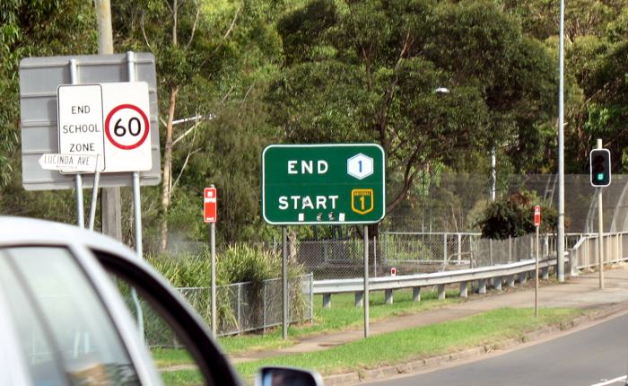 Highway route markers within the Sydney metroplitan area
vary. Some routes maintain from the
shield shape with a flat top, usual in Australia. Others are instead
hexagonal. Highway 1 switched from one to the other: marked as if they
are two different routes, but both routes were Highway 1. State routes
don't appear to change, though, continuing with blue shields. Moreover,
in New South Wales, at least on the Pacific Highways, there were no
reassurance markers. Instead, distance ("kilometrage?") signs included
the route marker at the top. Independent route markers are used in Western
Australia and in Victoria, even in the heart of Melbourne.
Highway route markers within the Sydney metroplitan area
vary. Some routes maintain from the
shield shape with a flat top, usual in Australia. Others are instead
hexagonal. Highway 1 switched from one to the other: marked as if they
are two different routes, but both routes were Highway 1. State routes
don't appear to change, though, continuing with blue shields. Moreover,
in New South Wales, at least on the Pacific Highways, there were no
reassurance markers. Instead, distance ("kilometrage?") signs included
the route marker at the top. Independent route markers are used in Western
Australia and in Victoria, even in the heart of Melbourne.
The M7 curves around northwestern Sydney, intersecting with the M4 motorway at an interchange in western Sydney. We continued on the M4 westbound. M4 ends near Emu Plains; at that point, the old Western Highway (Highway 32) is the route to take to the Blue Mountains and to Katoomba. While it's a divided highway, much of it is busy -- it's the only road to the Blue Mountains -- and there are frequent stoplights.
Katoomba and nearby Leura are old, turn-of-century, Victorian resort towns. We stayed at the Carrington, a restored resort hotel on a hill in the midst of the Katoomba CBD. In one of those coincidences that you couldn't make up, the hotel manager who checked us in had lived for many years in San Francisco before moving back to Australia a couple of years ago. She also informed us of the good news that the Iowa courts had thrown out the state's prohibition against same-sex marriage -- Iowa! -- along with lots of tart observations about the differences between American and Australian societies. She made the pertinent observation that "Australia is a nation of small towns" -- even though the big cities have most of the population, there's still a small-town feel to it, for both good and bad.
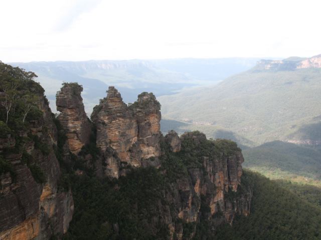
The Blue Mountains themselves are spectacular. There were lookouts all over the place. It seemed a bit odd at times: you'd drive through residential neighborhoods and, suddenly, the neighborhood would end and you'd be looking out over vast expanses of canyons and eucalyptus forests. Most well known are Echo Point and the Three Sisters (right), a long walk south from the Katoomba CBD. At dusk, under a cold, cloudy sky, it was still quite a sight. And, as always in Australia, there were the birds, squawking away.
The route back into Sydney, to get to the airport for our flight to Perth, went largely the same until reaching the M7 Westlink. This time, we went south on the M7 to connect with M5, the South Western Motorway. The motorways were smooth, but seemed small by American standards. My husband observed, "in California, these would be eight-lane freeways", but there were rarely more than six lanes on the motorways that we traveled.
The M5 is under the control of a *different* tolling authority than the M7, which seems unhandy, but at least the M5 had toll booths, so we didn't have to open up another account with another tolling company. You'd think they'd have figured out a way to have one agency handle all the billing but I guess not.
In order to make an exit to get gasoline on King Georges Road (also designated Highway 3, with a hexagon as usual for Sydney), we were stopped at a traffic light at the off-ramp from M5. It was the slowest traffic light I can recall. It took us about 10 minutes to get through the intersection, with traffic backing up on M5. Left turns on red were not allowed at that intersection, either.
A few kilometers east of King Georges Road, M5 goes into a tunnel on its way to the airport. There are a couple of interchanges going out of the tunnel, notably for Highway 66, the Princes Highway, a major route south from Sydney.
Our flight was on Virgin Blue, one of the two major Australian airlines. Contrasted to most American airlines, which these days adopt a "shut up, you're lucky we're here" posture, Virgin Blue employees actually acted as if they liked their jobs! It was a professional crew, and a relaxed flight. We landed at the domestic terminal of the Perth airport. While the terminal was up-to-date, it was surprisingly small for a city of Perth's size. The international terminal is separate, very separate: if you want to get to it from the domestic terminal, you have to drive several kilometers to reach it.
We picked up our rental car at the airport and drove into Perth (below, with the Kwinana Freeway, Highway 2, in the foreground.)
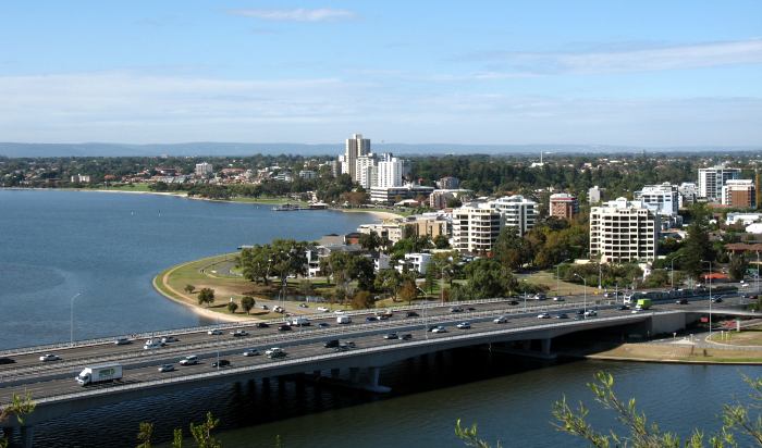
In a variety of ways, Perth reminded me of Albuquerque, though, of course, the comparison is not entirely apt since Perth is bigger, there are no mountains around Perth, and since Albuquerque doesn't have a light rail system. But Perth was dry and sunny, and clearly had been suffering a drought. Perth was well supplied with arterial streets, a freeway each through the northern and southern suburbs, and a short freeway around the north side of the CBD. Part of that latter freeway, the Graham Farmer Freeway, is in a tunnel.
We were staying in Subiaco, a pleasant inner suburb with plenty of historical character. My unofficial birthday dinner was at the Subiaco Hotel -- which, you have to understand, is a restaurant. The term "hotel" in Australia doesn't always mean a place with lodging. The word is often used to refer to a pub or an informal restaurant. Never mind that most restaurants are fairly informal these days, but I suppose the distinction once meant more than it seems to mean now.
Perth was the one place in Australia where we encountered warm, dry weather, though if we had been to Melbourne a week earlier, we would have been in a heat wave there. Even so, we didn't have much time to spend in Perth, but we did take a morning out to go to the Shipwreck Galleries at the Western Australian Museum in Fremantle, on the ocean shore. One of us is Dutch, so the galleries were especially notable for the number of Dutch shipwrecks and artifacts on display. There were maps and prints showing familiar scenes of Dutch maritime towns that I'm familiar with, including Vlissingen, Middleburg, and even Veere.
The centerpiece of the museum is the remains of the Batavia, wrecked in 1629, and notorious for the mutiny and massacres among the survivors (an unflinching account of the wreck and mutiny is Batavia's Graveyard by Mike Dash - though it was odd to get it as a gift from one's in-laws!). The restoration effort has been painstaking, and provides a glimpse into nautical technology of the 17th century.
Accounting for our morning in Fremantle, and a stop by a startlingly American-style shopping mall to the RAC, the Western Australian equivalent of the AAA (where they would not let me leave until they gave me a sticker card with the RAC's roadside assistance phone number!), we didn't get out of the Perth metropolitan area until mid-afternoon. One thing notable about Perth was the quantity of numbered routes, compared with Sydney which seemed to have many fewer such routes for a larger metropolitan area.
A note about that shopping mall: I said startlingly American-style because it was a standalone mall not in a central business district. Yet there was something distinctively different: a supermarket. In the mall. Now that's one-stop shopping.
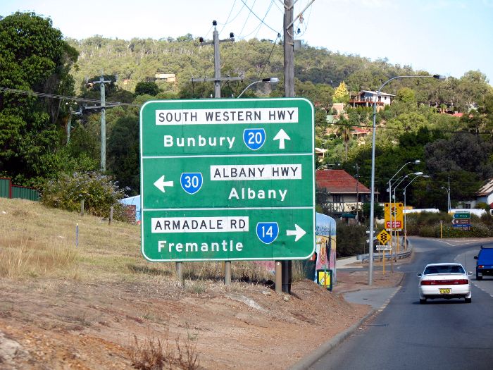 We had about five hours to go to reach Albany. We took Highway 30 out
of the city, which seemed to be endless
until the junction at Armadale, at which point we suddenly were in the country.
(Another photo of the highway in suburban Perth is at this
link.)
We had about five hours to go to reach Albany. We took Highway 30 out
of the city, which seemed to be endless
until the junction at Armadale, at which point we suddenly were in the country.
(Another photo of the highway in suburban Perth is at this
link.)
The highway is a fairly direct route between Perth and Albany, but it's still a long trip (400-plus km) on a two-lane highway. The highway itself was well maintained, notable because road maintenance and smooth pavement is something that is only a memory to Californians. Nearer to Perth, overtaking (passing) lanes were frequent; there were fewer of them the farther south you went. Part of the route is also designated as a tourist route, using a brown pentagon similar in shape to the standard US county route marker. There are also some routes whose only designation is as a tourist route. This system is used in other states as well.
At Mount Barker, 50 km northwest of Albany, the temperature suddenly dropped and it became foggy. Yes, it was ocean fog, a phenonemon that we couldn't escape even by going halfway round the world. It was dark and foggy by the time we reached Albany.
That's where having a mobile phone proved to be very handy: we couldn't find the B&B where we were staying. We had the number with us; I called, and, as it turned out, we were just about a kilometer away; we just had to keep going along the road that we were on. It wasn't as close to the Albany CBD as we had thought, but no matter, it was just a short walk from the beach and was a comfortable, relaxing place. It was another place where I wouldn't have minded spending an extra day or two.
As it was, it was the Easter weekend, which is a big deal in Australia. Some say it's second only to Christmas, some say it's as big as Christmas. Almost everyone gets off work Good Friday and Easter Monday, and some take the whole week after Easter. Fortunately, Albany is enough of a destination that there were attractions, restaurants, etc. open.
At an Albany newsagent, I bought a UBD atlas of southwestern Western Australia, with detailed maps of all the sizable towns in the region. It was a well-produced -- and useful! -- atlas.
We also made a side trip one day to the town of Denmark. It's not named after the country, but a person. So the local inhabitants call themselves "Denmarkers". The excellent Visitor Information Center is a tourist attraction in its own right: it hosts a barometer museum. The barometers were brought to Denmark by Bert Bolle, a Dutchman who decided to retire in Denmark, and brought his barometer collection with it. Included was a water barometer that he built. It was quite a task to get it halfway around the world and then reconstructed; a tower was built to house it, because it has to be 12 meters high to work and, yes, it really works. It takes a reading every six minutes. More details: http://www.bertbolle.com/
 On Easter itself, we left Albany to go to Margaret River. We went back
through Denmark and west toward Walpole. On the way to Walpole, there's
another "only in Australia" sight: the Valley of the Giants Tree Top
Walk.
On Easter itself, we left Albany to go to Margaret River. We went back
through Denmark and west toward Walpole. On the way to Walpole, there's
another "only in Australia" sight: the Valley of the Giants Tree Top
Walk.
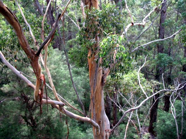
In the Walpole-Nornalup National Park, there is a forest of tingle trees. Tingle trees are related to eucalyptus. They're the last remnant of a much larger forest that dated to the time 65 million years ago when Australia and Antarctica were a single continent. Somehow, the climate of this part of southwestern Western Australia has remained compatible with the trees.
A walkway was built through the canopy of trees 13 years ago. It's more than 360 meters long, and reaches as high as 40 meters into the canopy. Yet the trees are much higher than that. The walkway was built to have minimum impact on the environment; thus, it sways as you walk on it (not for those prone to motion sickness). Each section of the walkway can only accommodate 10 people at a time. It's quite a sight and the only one of its kind anywhere.
After leaving the park and having lunch in Walpole, we were concerned about taking some of the side roads to reach our destination. We needn't have worried. Highway 1 through the parks east of Walpole and then north of Walpole going toward Manjimup was kind of rough and didn't seem to be as well maintained as other Australian highways. It was also rather narrow at some points.
We took Highway 10 as a shortcut to Pemberton via Northcliffe. Highway 10 was somewhat better than Highway 1, but still not up to the level that we had seen in other parts of WA. Highway 10 would have gone all the way north to Nannup, then back southwest on its way to Augusta, so we took an unnumbered route through the Hilliger National Park. The condition of the road was much better! It was wider and much smoother than the others had been.
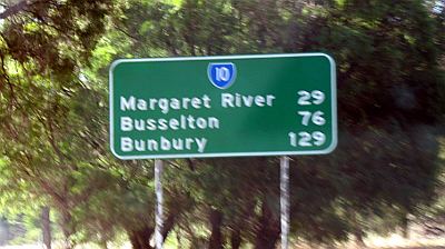 Our shortcut took us back to the Nannup-Augusta section of Highway 10, the
Brockman Highway (which I jokingly called the "Kent Brockman Highway";
sorry for the blurry sign photo; I have very few photos from this part of
the trip.) At
the western end of the highway, south Karridale, Highway 10 intersected
with itself. Yes, Highway 10 continued both north and south from the
Brockman Highway: south to Augusta, on the coast; and north, to Margaret
River, our destination. At that point, we were out of the sparsely
populated parklands, and in more of an agricultural area.
Our shortcut took us back to the Nannup-Augusta section of Highway 10, the
Brockman Highway (which I jokingly called the "Kent Brockman Highway";
sorry for the blurry sign photo; I have very few photos from this part of
the trip.) At
the western end of the highway, south Karridale, Highway 10 intersected
with itself. Yes, Highway 10 continued both north and south from the
Brockman Highway: south to Augusta, on the coast; and north, to Margaret
River, our destination. At that point, we were out of the sparsely
populated parklands, and in more of an agricultural area.
We spent the night in Margaret River, which, to me, only has one thing to recommend it: the ocean shore at the nearby suburb of Prevelly. The Indian Ocean was a deep, deep blue, with beautiful waves rolling in. Surfers were there on a Monday morning.
Otherwise, though, I felt Margaret River was somewhat of a tourist trip: nice enough, but overpriced for what you got, kind of like Monterey in California.
We left Margaret River on Easter Monday and headed north on Highway 10. As we went further north, there were more overtaking lanes and, approaching Bussellton, even a four-lane divided highway. We had lunch in the Bussellton CBD. Even though guidebooks seems to be dismissive of Bussellton, we had a different experience, thinking that it might have been a better place to stay than Margaret River. Less pretense and plenty of things to do, it seemed to us.
After Bussellton, came the hard part: getting back to Perth. Remember, it was Easter Monday. The southwest coast is a popular holiday destination for people from Perth. And then they had to get back home.
We tried to plan ahead, deciding to avoid Highway 1, the Coast Highway to Mandurah. Instead, we took Highway 20, the South Western Highway farther inland. The goal was to reach the Kwinana Freeway, Highway 2, whose southern terminus is at the town of Baldivis, not connecting either to Highways 1 or 20, but closer to 1. Even so, we though the coastal highway would be more crowded than the inland highway.
We had not reckoned with one traffic light, yes, just ONE traffic light, at a town called Pinjarra.
About 10 km south of Pinjarra, traffic came to a complete halt, and then crept along and crept along and crept along. It took us more than an hour to reach Pinjarra. We were looking at maps trying to figure out the best way of getting off the highway and cutting over to Mandurah to join the Coast Highway. But we wondered whether we would just be trading one problem for another.
We finally reached Pinjarra's only traffic light, in its CBD. The light was cycling as usual. There was no traffic on the road to Mandurah. But the light cycled through. We crossed the intersection and then -- aha! -- traffic was flowing smoothly. It was at the speed limit! That one traffic light, when confronted with a high traffic count, caused traffic to back up at least 10 km. Later, on local radio and TV, we heard that the backup was even greater later in the afternoon.
After a while, traffic slowed down again, though not nearly as badly as before. At last we reached an east-west highway, Highway 22, and crossed over west to pick up the freeway. There was slow traffic there, too, but not the way it was at Pinjarra. It also started raining. We had hoped to spend more time in Perth that day, but it wasn't to be. Still, we did reach our hotel in the Perth CBD in the late afternoon.
The next day, we spent the morning in Kings Park, had lunch at the airport due, unfortunately, to timing, then flew from Perth to Melbourne, also on Virgin Blue.
Next: Part Three, Melbourne and done.
Oakland, California
E-mail: Please see the Contact Information page.