Part One
I've always wanted to visit Australia. Earlier this month, I finally did it, spending three weeks in New South Wales, Western Australia, and Victoria.
My husband and I did quite a bit of driving in New South Wales and Western Australia. In NSW we went up the Pacific Highway from Sydney to Coffs Harbour, then drove back and out west to the Blue Mountains. In Western Australia, we made a circle, starting in Perth, going to Albany, then going to Margaret River, and thence back up to Perth.
This set of posts will focus primarily on roads and road-related sights, but there was so much more to the trip, of course, and so various other observations will sneak into this post from time to time.
Generally speaking, Australia feels in many ways like the United States did before suburban sprawl became so noxious, and before Wal-Mart and their like homogenized shopping. It's not that Australia doesn't have sprawl; it certainly does have some. Even so, downtown (or "CBD", for central business district) areas are still vibrant, with lots of people on the streets. In most towns, the downtown area is still the key shopping district. There are some chain stores present, but there seem to be more than a few local merchants, too.
There is also somewhat of a gap between the capital cities and the "country". That's likely because the big cities are so much bigger than the larger cities in the country areas. For example, Perth is the biggest city in Western Australia at just under two million. The second biggest is Albany at around 30 thousand. But even Albany has "suburbs" - though the Australian meaning of "suburb" is more comparable to the Californian term "district", i.e. a group of related neighborhoods.
As for wildlife, the koalas and kangaroos are the most famous, but what I didn't realize until I got into some of the "country areas" was how different the *birds* were. They're noisy. You really don't need an alarm clock; just let the kookaburas and lorrikeets wake you up in the morning!
Going ahead for a moment, the owner of a B&B where we stayed near Coffs Harbour, one night showed us the source of a very loud noise: a little frog. The B&B owner explained, "every animal is looking for food or sex, and this one's looking for sex!"
Just as odd, we had lunch one day in a restaurant in the Sydney Botanical Gardens, next to a cluster of flying foxes -- bats! -- that were active during the daytime, and quite vociferous and loud.
I'll mention other examples later, but let's get on the road.
We started in Sydney and went without a car for a few days. In part, that was to get over jet lag from the flight; in part, that was to get used to traffic coming at us from the other side of the road.
 Yes, no discussion of
Australian roads is complete without a discussion of driving on the
other side of the road. It's not that hard, and possibly even makes
one a better driver, at least temporarily, because you're paying more
attention to what you're doing. A minor challenge is making sure you're
not driving *too* far left in your lane. That came as a surprise to
me, but I got used to it.
Yes, no discussion of
Australian roads is complete without a discussion of driving on the
other side of the road. It's not that hard, and possibly even makes
one a better driver, at least temporarily, because you're paying more
attention to what you're doing. A minor challenge is making sure you're
not driving *too* far left in your lane. That came as a surprise to
me, but I got used to it.
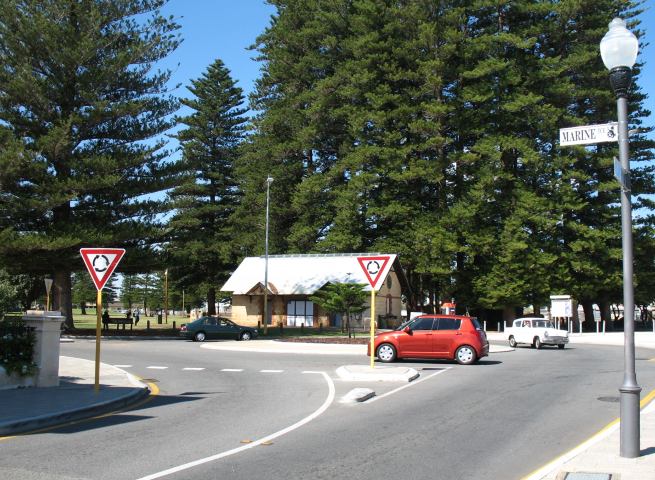
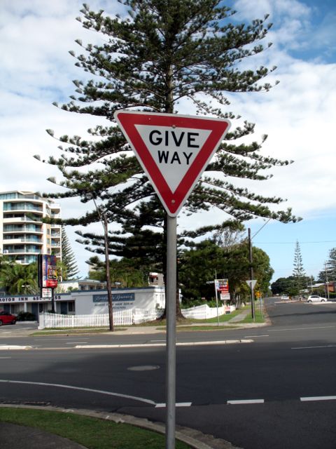
A bigger challenge comes at roundabouts. There are lots of them in Australia. They even get their own special "yield" sign: the Australian yield sign at a non-roundabout is a red-bordered triangle that says "GIVE WAY"; at a roundabout, "GIVE WAY" is replaced by a symbol of three arrows arranged in a circle, all pointing clockwise.
Note: The roundabout at left is actually in Fremantle, Perth, Western Australia. It happens to be the best illustration that I have of a roundabout with the specialized "yield" signs. The "GIVE WAY" sign in the next photo below is in Forster, in the Myall Lakes region of New South Wales.
 Combine unfamiliarity with roundabouts with driving in the opposite direction
from which one is accustomed and, let's not forget, signaling protocol,
adding up to a lot to keep track of. Fortunately, most Australians seem to
be patient, well mannered drivers. For example, I never even heard a horn
honk while driving. Speed limits were observed by most drivers. There were
plenty of speed cameras which appeared to be well-marked. We also observed
the occasional use of radar by police officers over the Easter holiday
period. It would be refreshing to see this kind of speed enforcement
in the United States.
Combine unfamiliarity with roundabouts with driving in the opposite direction
from which one is accustomed and, let's not forget, signaling protocol,
adding up to a lot to keep track of. Fortunately, most Australians seem to
be patient, well mannered drivers. For example, I never even heard a horn
honk while driving. Speed limits were observed by most drivers. There were
plenty of speed cameras which appeared to be well-marked. We also observed
the occasional use of radar by police officers over the Easter holiday
period. It would be refreshing to see this kind of speed enforcement
in the United States.
But back to Sydney: since we didn't have a car, we took public transit everywhere. While Sydney made the mistake of tearing out its streetcar system back when so many other cities did (except for Melbourne, San Francisco, and a few others) its bus system largely makes up for it. Buses were frequent and convenient. Moreover, there's an excellent commuter rail system, and even a monorail. The monorail seems to be a bit of a novelty, and expensive, but is the easiest way to go between the CBD and the near-western inner suburbs, notably Ultimo.
Ferries are another form of public transit. During one wet and stormy day, we took the ferry to Manly, across the harbor to the north and east. The weather was so stormy that, at the point where ocean currents come into the harbor, we were advised to sit down -- and, indeed, it was a rough ride (as in, if you were standing, you probably would have fallen over. It was a good thing that I don't get seasick.
Unfortunately, because of the weather, we didn't see Manly at its best, though there was a nice small local museum focusing intensely on local history.
The weather was much better the next day when we were at the Rocks, the site of the original European settlement of Sydney. The construction of the Harbour Bridge caused the area, already in decline, to deteriorate further, until the 1970s when the historic nature of the buildings was finally recognized. One of our guidebooks called it a "tourist trap", but it was a pleasant area nonetheless, and also gives you a sight of the bridge from a "worm's eye" angle.
At the Visitor's Information Center at the Rocks, I picked up a copy of Gregory's Down Under Map of the World. It's a map where "up" is south and "down" is north. It was perfect for me, the smartass who asked his fourth grade teacher if maps in the Southern Hemisphere had south at the top.
After a few days, we picked up our car rental in the CBD and then had to figure out how to get out of Sydney to the north. Yes, the roads are well marked, but Sydney's system of freeways and motorways is not pervasive, with some obvious missing links; getting out of Sydney to the north is one of those missing links.
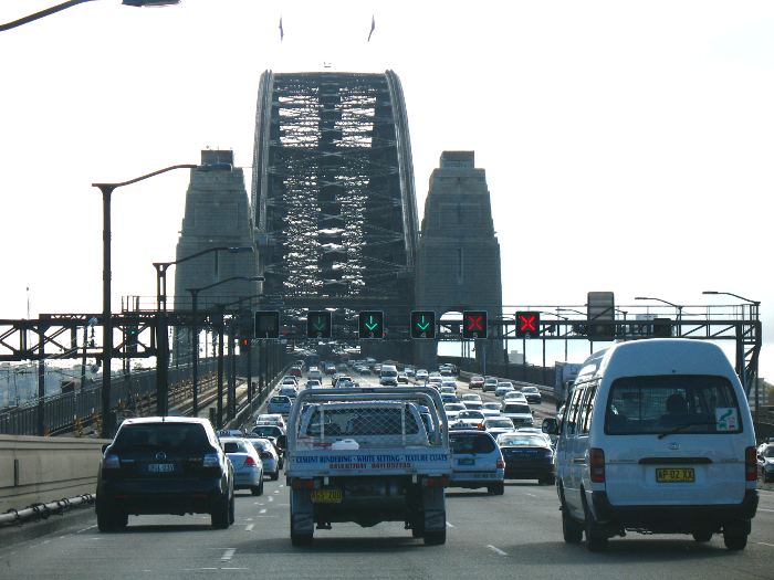
We crossed over the Harbour Bridge, a Sydney landmark that was being repainted at the time, and entered onto Highway 1 through the northern suburbs of Sydney. That's a freeway, but not a very long one. Just before the Lane Cove Tunnel, we had to take an exit to continue north on Highway 1, which, at that point, is the Pacific Highway and runs along city streets.
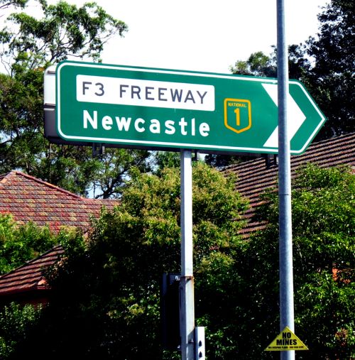
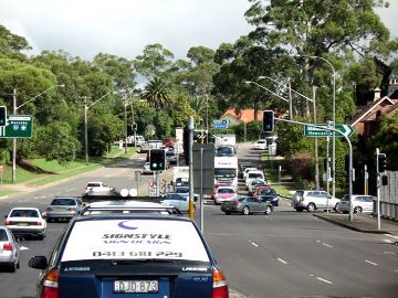 We went through a
succession of suburbs until reaching the southern terminus of the
Sydney-Newcastle Freeway at Wahroonga. Highway 1 continues onto
the freeway from this entrance.
(A larger version of the photo of the intersection is at this
link.)
We went through a
succession of suburbs until reaching the southern terminus of the
Sydney-Newcastle Freeway at Wahroonga. Highway 1 continues onto
the freeway from this entrance.
(A larger version of the photo of the intersection is at this
link.)
Surprisingly quickly, we reached an extensive national park, making it a scenic drive. The freeway is also referred to as the "F3 Freeway" in the Sydney area -- even though it's Highway 1.
The freeway actually goes around Newcastle, and ends at the New England Highway at Beresfield. The northern terminus is convoluted, and also appears to function differently in the northbound direction than in the southbound direction. After going through a series of traffic lights (and, as I recall, one roundabout), where Highway 1 seems to "disappear" for about 3 km, the road continues at the Highway 111 junction at Hexham.
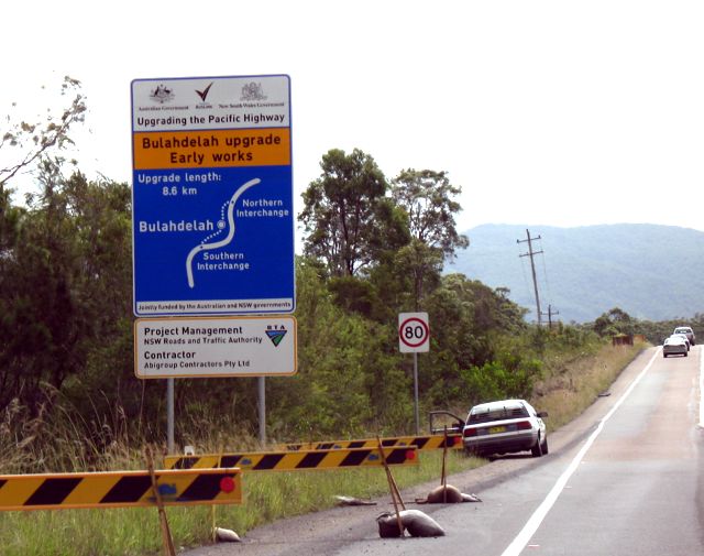 That wasn't the end of the dual-carriageway. In fact, New South Wales
is in the midst of an extensive program (typical sign at left)
to upgrade most of the Pacific
Highway to a dual-carriageway configuration, with interchanges for
major towns. Some grade crossings will remain.
That wasn't the end of the dual-carriageway. In fact, New South Wales
is in the midst of an extensive program (typical sign at left)
to upgrade most of the Pacific
Highway to a dual-carriageway configuration, with interchanges for
major towns. Some grade crossings will remain.
While Australian cartography is of uniformly excellent quality, one shortcoming of the offerings from most publishers is the lack of indication of *non-freeway* dual-carriageway roads. The only publisher that we found to consistently show such roads was UBD. On our way north, it was kind of a guessing game, though, because we were using maps from the NRMA, the New South Wales equivalent of the AAA. (The Sydney branch of the NRMA was eager to help with maps of ALL the areas we were visiting, and didn't charge us for them!) The NRMA maps were comparable in scope to the regional maps published by the CSAA in northern California, but divided roads, other than freeways, weren't marked as such.
We stopped for lunch at the next large town north of Newcastle, Raymond Terrace. At first glance the downtown area appeared to be small. But then we saw a parking garage which in turn was attached to a shopping mall. The mall had an entrance onto the main street of the downtown area, too. It was well integrated into the area, much better than you would see in, say, a Missouri town.
From there we continued northward. As we went north, there were fewer dual-carriageway sections. Even where there was two-way traffic, "overtaking lanes" for passing were frequent. Even so, I'm glad we made the trip before the Easter holiday, where, I imagine, there would have been a lot of congestion. Easter is a big deal in Australia, comparable to the Christmas holidays, with Good Friday and the following Monday as public holidays. Fall school holidays begin at that time, too. We were a week ahead of the rush; we would be in Western Australia for that weekend.
We had originally planned to stop at Port Macquarie. As it so happened, though, the weekend before Easter is a big deal in Port Macquarie, because the town hosts one of the biggest triathlon competitions in Australia. So hotel rooms could not be found for that weekend, and, instead, we had reserved a B&B quite a bit farther north, near Coffs Harbour.
While we were in Sydney, our Coffs plans had entailed some nailbiting, as unusually heavy fall storms had flooded out Coffs Harbour, particularly its CBD. It was a frequent topic on local radio and TV news, and in the newspapers. Fortunately, I had arranged for an Australian cell phone before leaving the US; as a consequence, I was able to call the B&B to find out that everything was OK there. And, indeed, Coffs residents and businesses moved fast to clean up after the flash floods that had hit. We were in the Coffs CBD on Saturday and, aside from one business that was still closed from flood damage, everything was as usual. We bought a copy of the local newspaper, the Coffs Coast Advocate, which had lots of photos of the damage.
The Coffs CBD was also where I got my introduction to an interesting small-town Australian habit: backing into angle parking spaces. Now try doing that when sitting on the opposite side of the car from which you're used to sitting, and from the left side of the roadway! It's one example where I observed the patience and courtesy of Australian drivers - very fine indeed!
Development, such as condo towers or hotels, has impinged very little on the coast at Coffs Harbour. There is a nice overlook in the southeast part of the city that gives you about a 270-degree view of the coast. It's quite beautiful. We ate dinner a couple of nights at a nearby town, Sawtell, where, we were told, condo developments were about to be built. So, in a few years, I imagine that the coast won't look nearly as nice as it does now.
Along the roadside in and near Coffs Harbour, you'll see banana trees. The B&B owner told us that bananas will grow there, as long as they're on a slope facing the ocean. (Official latitude for Coffs Harbour is 30 degrees, 18 minutes.) Then again, that land also is in demand for building sites because everyone wants an ocean view. So the banana trees are gradually being replaced by development. Oh, well.
The Pacific Highway south of Coffs Harbour had recently been rerouted onto a new stretch of dual carriageway highway; on the old Pacific Highway, I saw *both* kinds of koala warning signs along the road.
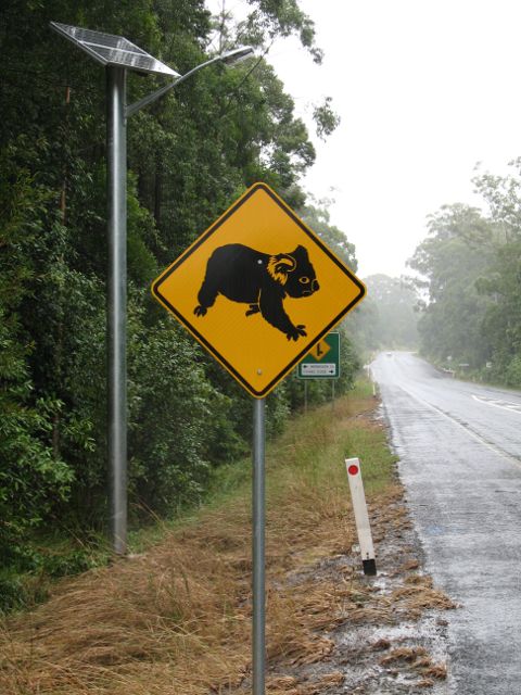
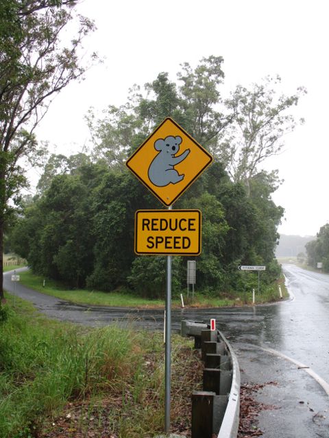
One type is all in black (left); another (right) shows a stylized koala in white; both are on a yellow diamond. Yellow diamonds are the standard for Australian warning signs. The mix of familiar and unfamiliar signing practices may be best represented by speed limit signs. They're on rectangular blanks, just as American speed limit signs would be, but they're shown as a number inside a red circle, European-style. And, of course, the metric system is used. Only the United States, it appears, is stupid enough not to use the metric system. Fonts are almost always the FHWA series of fonts; no Clearview was seen at all. Freeway guide signs have a green background, but often have diagrams that are similar to those seen on European motorways (where the background would be blue and where, outside the Netherlands, the fonts wouldn't be FHWA fonts).
Next: Part Two, more New South Wales, plus Western Australia.
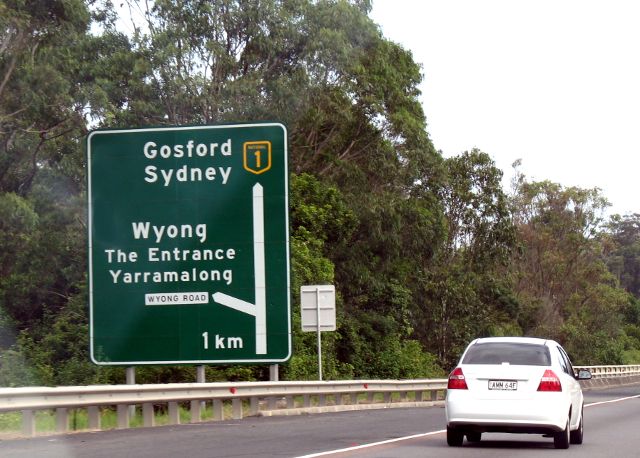
Above: Typical freeway exit diagram, on Highway 1 southbound near Wyong.
Oakland, California
E-mail: Please see the Contact Information page.