US 71 was originally planned in 1951 as a freeway through south-central Kansas City. But the freeway would have cut a swath through an older, established neighborhood. The neighborhood fought back, obtaining a settlement in 1985 that called for part of the road to be built as a parkway.
A freeway was still built from Bannister Road north to 75th Street. That stretch of road opened in December 1990.
Until 2001, all but one commercially available map of Kansas City, regardless of the scale of the map, showed US 71 as a controlled-access highway with interchanges in the south-central part of the city on the segment between Brush Creek and 75th Street. There is one interchange, for 63rd Street and Meyer Boulevard, but there are also intersections for other arterial streets in the area. Major American mapmaker Rand McNally has subsequently corrected its maps. The official 2001-2002 Missouri highway map still did not show US 71 correctly, although it also avoided showing non-existent interchanges. The official 2005-2006 Missouri highway map does not make a clear distinction between the freeway and parkway segments of Watkins Drive. The symbols used for non-Interstate divided highways were changed in that edition.
The portion of US 71 that the mapmakers have a hard time getting right is between 63rd and 75th Streets. It was constructed as a parkway over a 2 1/2 year period. There was ample controversy regarding the construction. Engineers of the Missouri Highway and Transportation Department continued to advocate a freeway, which they said would be safer than the parkway. A few area residents agreed. But many more advocated sticking with the 1985 court settlement. They were supported by Kansas City Mayor Emanuel Cleaver, who successfully obtained a $700,000 allocation for beautification work along the parkway as well.
The landscaping project eventually cost nearly six million dollars, reportedly one of the largest freeway and parkway landscaping projects in the United States. The total cost of the roadway was estimated between $220 million and $300 million.
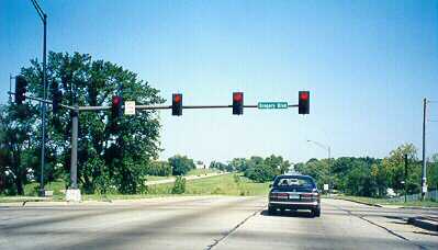
On these pages, the photos of Watkins Drive, then completed to Swope Parkway, were taken August 29, 1998. The intersection shown is Gregory Boulevard crossing Watkins Drive.
The National Geographic deluxe atlas published in the summer of 1998 came closest to any other map of the time at getting this right. It shows a small segment as a divided boulevard with at-grade intersections. But it still misses the mark regarding the intersection at Gregory Boulevard (71st Street) and Watkins Drive (US 71). Does this look like a freeway?
One interchange remained, at Meyer Boulevard and 63rd Street, to serve traffic for both the nearby Research Medical Center and Kansas City's largest area of parkland, Swope Park. The segment north to 63rd Street was opened in July 1994.
More photos of Watkins Drive
- Turning Out at 67th Streets
- One of the short exit lanes that are found along Watkins Drive to help link the road to the surrounding neighborhood. This one is at 67th Street. Others are at 60th and 57th Streets.
- A Big Brown Sign
- A big brown sign, which looks like a "big blue sign" on a freeway advertising gasoline, food, and lodging services, instead advertises the attractions at Swope Park, not far to the east of US 71. Identical signs also are near the Gregory Boulevard exit of I-435.
- The Maps Do Get This One Right
- At our next step northbound on Watkins Drive, we come to the Meyer Boulevard/63rd Street interchange (which all recent maps do get right). An interchange was built at this location to meet the requirements of heavy traffic (by Kansas City standards) at Research Medical Center, as well as traffic to and from Swope Park.
- Bridging the Parkway
- An important part of the beautification effort for Watkins Drive has been the construction of ornate bridges over the roadway. This bridge carries Meyer Boulevard over the depressed roadway. In addition, it has a pedestrian walkway on its south side.
- Signaling More Wrong Maps
- Once north of 63rd Street, there are more opportunities to find mapping errors as the road becomes a parkway once again. The next set of traffic lights is found here at 59th Street. There's a signalized intersection at 55th Street as well. At this point in 1998, you would have been close to end of the road.
- The Temporary End of the Road
-
 The roadway between 63rd Street and Swope Parkway was opened to
traffic in August 1996. Before the road could go on, four bridges
had to be completed, including one over Brush Creek.
At this point,
US 71 was rerouted back onto Prospect Avenue. The roadway curves
northwestward here, and crosses over Prospect. You can see
Prospect behind the US 56 West sign.
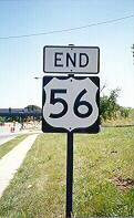
This interchange also marks the eastern terminus of US 56,
as indicated by the END sign on Swope Parkway (shown at right;
also check out a close-up view of the sign)
just before the traffic lights for the ramps on and off US 71.
The roadway between 63rd Street and Swope Parkway was opened to
traffic in August 1996. Before the road could go on, four bridges
had to be completed, including one over Brush Creek.
At this point,
US 71 was rerouted back onto Prospect Avenue. The roadway curves
northwestward here, and crosses over Prospect. You can see
Prospect behind the US 56 West sign.
This interchange also marks the eastern terminus of US 56,
as indicated by the END sign on Swope Parkway (shown at right;
also check out a close-up view of the sign)
just before the traffic lights for the ramps on and off US 71.
At the time these photos were taken, bridge work was proceeding on the four bridges over Swope Parkway, Brush Creek, and Brush Creek Boulevard. Work on the roadway north of Brush Creek actually began before work on the bridges started, a point of some controversy. Nonetheless, the next section, from Brush Creek northward to 31st Street, opened in July 1999.
State and city officials were able to work out an accelerated timetable, pushing up the completion date for the entire project from 2005 to 2001. The final section of Watkins Drive, between the downtown freeway loop and 31st Street, opened October 22, 2001.
Almost immediately, commuters using the route complained of long backups at the traffic lights at 55th, 59th, and Gregory Boulevard during peak periods. State highway engineers had to remind the public that the road was built with the intersections as the result of a court settlement. (Without that court settlement, the freeway might not have been built at all.) As an engineer for the Missouri Department of Transportation told the Kansas City Star regarding the traffic lights, "I think they're here to stay."
Denver, Colorado
E-mail: Please see the Contact Information page.