Note that this site hasn't been updated in several years. Some information, particularly when correlating historic routes with current routes, may now be out of date.
Missouri's present-day road system is the direct descendant of a plan passed by the Missouri General Assembly in Missouri's 100th anniversary year, 1921. That plan, known as the Centennial Road system, laid out the basic outlines for the state highway system that's still in place today.
The thick lines on the Centennial Road System map below, representing 1500 miles of paved highways, are largely the same highways that are the backbone of Missouri's road network today. (For instance, that line across the center of the state, State Highway No. 2, is now, for the most part, the route of Interstate 70).
The numbers may have changed, of course, and a couple of search programs will show you that, while the numbers may have changed, many of the roads are still around. They may be on slightly different routes, but the basic ideas laid out by the Missouri General Assembly in 1921 still are very much alive today.
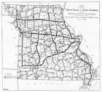
Left: Map of the Centennial Road System, as authorized by the Missouri Legislature's 1921 special session, shown in the Missouri State Manual for 1923-24, published by Secretary of State Charles U. Becker.
You can also see a larger version of this map (236K), as well as the original 1922 system map (430K) as approved by the Missouri Highway Commission (contributed by David Backlin).
The Early 20th Century
The early history of the Missouri highway system, as related in the state manuals (official biennial almanacs) of the 1920s, placed heavy reliance on Missouri counties for road-building activities. As the state highway department's article in the 1923-24 State Manual stated,
Prior to 1907 highway improvement was left entirely to the county courts of the several counties. Each county being an independent unit in road matters, thought only of its immediate needs and failed to recognize the importance of inter-county seat connections.
There was also a lack of engineering talent of sufficient experience to advise the county courts along comprehensive lines. There was little or no co-ordination of plan and effort between the adjoining counties. Highway transportation needs, then accentuated by the motor vehicle, were not being properly met.
In 1907, the state legislature passed a law requiring county highway engineers to be appointed; in 1909, a general road fund was established. But developments brought about new legislation in 1913 to establish county highway boards and state aid for highway construction.
The Centennial Road Law of 1921
The first big development in Missouri highways came in 1921, the occasion of the state's 100th anniversary, when a special session of the legislature enacted the Centennial Road Law, establishing the modern-day Missouri Highway Commission and an extensive road network. A special election in which voters authorized $60 million in bonds for roadbuilding set the stage for the session. "In order that there might be no hindrance of regular legislation at the Fifty-first General Assembly, Governor [Arthur M.] Hyde announced that a special session would be held for the purpose of enacting such laws that were necessary to properly expend the money." (State Manual, 1921-22)
The law created the modern-day Missouri Highway Commission. The Highway Department's article in the 1923-24 State Manual continued,
The outstanding feature of the Centennial Road Law is the provision for a system of highways totaling approximately 7,630 miles, penetrating each county in the state, connecting county seats and other centers of population. This law designates the roads in each county and the Commission has little or no option to change routes unless conditions make the location prohibitive, Provision is further made that each county shall have allotted to it a sum based upon the ratio of the estimated cost (said estimate being in no case less than $6,000 per mile) of the state road mileage in the county to the estimated cost of such mileage in all counties. The funds to meet this provision are to be obtained by the sale of bonds totaling in the aggregate $60,000,000. The law also provides for a higher type road than clay bound gravel or its equivalent, and authorizes the Commission to make a selection of such roads approximating 1,500 miles in length. In this latter case, the location and alignment of the designated roads may be modified in the interest of economy and directness of route.
The goal of the road system that was created by the legislature on July 30, 1921 was to provide each Missouri county two roads connecting it with other counties. One such road would run north and south; the other would run west and east. The Highway Department was allowed to designate which 1,500 miles of road would be paved as a "higher type road".
Another election in November, 1924, allowed the timetable for road construction to be accelerated. More money was available through a 50 per cent increase in vehicle registration fees and the addition of a two cent per gallon gasoline tax. One thousand miles of road were constructed in 1925 by 177 contractors working on 528 projects. The highway department estimated that 30 to 50 miles of road were being built per week. (State Manual, 1925-26)
Proposition Three, 1928
When the last of the Centennial Road bonds were sold in 1927, the rate of work decreased by half. As the State Manual for 1929-30 noted, "it became apparent that such slow progress would not meet the needs and wishes of the motor vehicle owners".
The Automobile Club of Missouri proposed a $120 million bond issue but "the State Highway Commision felt that this was too much", instead suggesting a $60 million bond issue. (State Manual, 1929-30) A compromise settled on a $75 million issue, approved by voters (along with changes to the state constitution) as Proposition Three in November, 1928. As the highway department proclaimed in its State Manual article for 1929-30, "the adoption of this constitutional amendment marks the beginning of a new era in road building in Missouri".
Proposition Three expanded the primary road system and established a new supplementary highway system, also described as "farm-to-market roads". The supplemental system was introduced in 1931 with the first supplemental routes appearing on the 1932 official Missouri road map.
Proposition Three also authorized, for the first time, state roads in Kansas City and St. Louis, which had been forbidden in earlier constitutional amendments (evidently rural roadbuilding took priority before city traffic problems became too great to ignore). From the State Manual for 1929-30:
This amendment also provides that the proceeds of the $75,000,000 road bond issue shall be expended for the following six purposes:
- To expedite the completion of the 7,640-mile Centennial Road Law System.
- To reimburse counties and other civil subdivisions for roads taken over.
- To add three hundred miles to this Centennial Road Law system for the purpose of rounding out the system.
- To relieve traffic congestion in this vicinity of St. Louis and Kansas City.
- To construct supplementary state highways and bridges in each county of the state.
- To make connections to state parks.
(text omitted)
This amendment offers the following basic advantages
- Stability to the road program for a period of at least ten years.
- Continuity of administrative policy.
- Completion of the Centennial Road Law system by 1934 instead of 1937 thereby reducing the operating cost to motor vehicle owners enough to offset the interest on the bonds.
- Needed connecting links to the state system and making state parks accessible and more inviting to the tourists.
- Reduction of the traffic hazard, by relieving congestion in metropolitan areas.
- A greater degree of road penetration, and therefore a greater service to the people in remote sections, due to increased mileage.
- No property tax.
Under the provisions of this constitutional amendment, the state road program takes on new life and a wider scope.
(text omitted)
The several phases of the road program up to 1937, are indicated in the adjoining tables:
Scope of Program.
     Centennial Road Law System-
         1,599 miles of primary roads
         5,927 miles of secondary roads
         -----
         7,526 miles
               Proposition No. 3-Additions-
           300 miles additional state roads
         7.000 miles state supplementary (farm to market)
           200 miles (approximately) of additional roads
               and widening in congested sections
               around St. Louis and Kansas City.
         ------
   Total 15,026 miles.


 Estimated Expenditures.
    It is estimated that the $75,000,000 bond issue together
    with annual basic revenues will
    permit of the following expenditures by the end of 1937:
    Expediting the completion of the present state system    $100,787,340
    300 additional miles of state roads and park connections    7,000,000
    Supplementary state highways (farm to market)              40,000,000
    Relief of traffic congestion around St. Louis
    and Kansas City                                            10,937,911
                                                             ------------
                                                             $158,752,251
Also included in the expense figures were the costs of upgrading roads that had already been built but that were not up to more exacting standards that were subsequently implemented. (remainder about bridges omitted)
Road signs were also becoming important, as this excerpt from the 1929-30 State Manual made clear:
Especial mention should be made of the system of marking Missouri state highways, for it is receiving praise from many out of state travelers. What was formerly a convenience has become so necessary to the comfort of travelers that now it is deemed a necessity.
Radio road reports (on the state's station, WOS, which shared time with KFRU in Columbia), road maps, and beautification projects also were activities that the highway department considered increasingly important as the state's highway system continued to develop and expand.
Denver, Colorado
E-mail: Please see the Contact Information page.