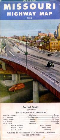
On its front cover (above), the 1952 state highway map featured what appeared to be the Southwest Trafficway in Kansas City, one of the few expressways in Missouri at the time.
The 1952 official Missouri highway map differed considerably in appearance from the maps of later years. Most notable was the map's use of the Missouri state outline for numbered state highways (for which later maps used a plain circle) and the predominant use of all-upper-case type. This style was first used in 1950, which was the first map to be typeset rather than drawn by hand.
It's a snapshot of a time with no freeways except in Kansas City or St. Louis. Even in those cities, there were few freeways. But on the front cover (left), the map showed a drawing or photo of what I'm sure is Kansas City's Southwest Trafficway, judging by the buildings depicted in the background.
I even think that this scene depicted the trafficway's overpass over Southwest Boulevard, based on the angles of the roadways shown.
From this page, you can access fair use excerpts of the map. Due to its age, the folds are noticeable, but the map itself is actually in very good condition.
Note: These are huge scans, running up to 700 KB. This was necessary in order to show the detail that this map provides. The areas shown by the scans overlap.
Inset Maps
Included around the margins of the map were inset maps for 37 cities, including St. Louis and Kansas City, of course, but also including quite a few smaller cities in the state. In subsequent years, most official maps continued with the insets, while a few, such as the 1956 map, didn't. The last official map with an extensive collection of inset maps was the 1969 map.
The 1952 insets appeared to be hand-drawn, unlike the main map. They provide a window into a world where highways rarely bypassed cities and, of course, there were few freeways or divided highways. The following cities had inset maps on the 1952 map (fair use excerpts):