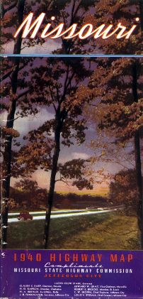
The cover photo (above) for the 1940 state highway map showed a divided highway. There were relatively few such highways at the time, mostly in the Kansas City and St. Louis metropolitan areas. This scene wasn't identified on the map. This was the first official state highway map to have a color photo on the cover, though there were color drawings in a couple of previous years, including 1939.
While the 1940 official Missouri highway map continued to be printed in full color, and, as in 1938, it continued to use a yellow background to differentiate land in Missouri from land in other states. Unlike the 1938 map, though, route logs were not included on this map. Inset maps of the Kansas City and St. Louis metropolitan areas were inserted on the front side of the map. The back side of the map featured photos of highway scenes around the state.
From this page, you can access fair use excerpts of the map. Due to its age, the folds are noticeable, but the map itself is actually in very good condition.
Note: These are huge scans, running up to 400 or 500 KB or even more in size. Such large file sizes were necessary in order to show the detail that this map provides. The areas shown by the scans overlap.