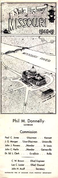
On its front cover (above), the 1948 state highway map featured a drawing showing US highways 50, 54, and 63 coverging on the state capitol in Jefferson City. Naturally, the state highway department building is shown in the cover art, too. The routes shown on the cover don't accurately reflect the actual routes that the highways traveled on the streets of Jefferson City. Compare this drawing with the inset map for Jefferson City on the inset of the map sheet. That inset map shows the actual routes for the highways.
The 1948-1949 official Missouri highway map differed considerably in appearance from the maps of later years. Most notable was the map's use of the Missouri state outline for numbered state highways (for which later maps used a plain circle) and the predominant use of all-upper-case type.
It was also the last map to be fully hand-drawn. Beginning in 1950, the main map was typeset, though insets continued to be hand-drawn for a few more years. The 1952 official map is another example of the official map's appearance during the early and mid 1950's.
The cover is still in black-and-white, possibly reflecting the austerity of the years immediately after World War II.
From this page, you can access fair use excerpts of the map. It is in excellent condition.
Note: These are huge scans, running around 400 or 500 KB in size. Such large file sizes were necessary in order to show the detail that this map provides. The areas shown by the scans overlap.
Inset Maps
Included around the margins of the map were inset maps for 38 cities, including St. Louis and Kansas City, of course, but also including quite a few smaller cities in the state. In subsequent years, some official maps continued with the insets, while others such as the 1956 map didn't. The last official map with an extensive collection of inset maps was the 1969 map.
The following cities had inset maps on the 1948 map (fair use excerpts):