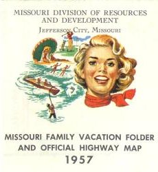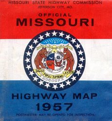
There were two versions of the official 1957 state map. The version from the state highway commission used a motif resembling Missouri's state flag (above). The version from the Missouri Division of Resources and Development (below) was more clearly aimed at tourists. Both versions were dated January 1, 1957. The front side of the map is the same in both versions. The rear side is different. The highway commission map features a map of roadside parks and bridges, while the resources division map shows photos of state parks and a highly stylized map showing the regions of Missouri.
The 1957 official Missouri highway map is in a modern style similar to the 1956 map, with the use of mixed-case fonts and a circle for numbered state highways, rather than the state outline as done for maps earlier in the decade (such as the 1952 map). Important routes were shown in red, secondary numbered routes and almost all supplemental routes were shown in dark blue. Dark blue was used instead of black on the front side of the map.
From this page, you can access fair use excerpts of the map. Due to its age, the folds are noticeable, but the map itself is actually in very good condition.
Tech Trivia: These are huge scans, running up to 700 KB. This was necessary in order to show the detail that this map provides. The areas shown by the scans overlap.
- Bootheel
- Central region
- East Central region
- Northeast Central region
- Northwest Central region
- Northwest corner
- South Central region
- Southwest corner
- West Central region
- New Jefferson City bridge (on reverse side of the map)
- Roadside Parks (on reverse side of the map)
Inset Maps
Included around the margins of the map were inset maps for 40 cities, including St. Louis and Kansas City, of course, but also including many of the smaller cities in the state. In the previous year, the 1956 map only had inset maps for Kansas City and St. Louis, breaking with tradition. Obviously, the tradition was restored the next year. Both the highway commission version and the state resources and development division version of the 1957 map showed the inset maps. The last official map with an extensive collection of inset maps was the 1969 map.
The 1957 insets were of several sizes. The smallest cities were shown with the smallest insets. Because those insets did not scan particularly clearly, I have written on each page showing an inset a description of the numbered routes shown on the inset map. I've done this for all inset maps, including the larger ones. The following cities had inset maps on the 1957 map (fair use excerpts):