The 1959 official Missouri highway map (front cover, left) was the first official map published that displayed completed segments of the Interstate highway system. There weren't very many of them yet: Interstate 70 had been built near Columbia and St. Charles, Interstate 44 was represented by a segment near Springfield, and Interstate 29 had been designated in Kansas City.
The color scheme of dark blue for most routes and red for primary routes, first used in 1954, continued on the 1959 edition of the map, with the addition of new symbols for Interstate highways. See the map legend for more details.
From this page, you can access fair use excerpts of the map. Due to its age, the folds are noticeable, but the map itself is actually in very good condition. Please note that these are large scans, running up to 700 KB, necessary in order to show the detail that this map provides. The areas shown by the scans overlap.
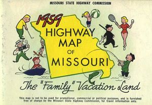
The back cover of the map included space for a mailing address, and featured an outline of Missouri surrounded by cartoon characters engaging in different outdoor activities.
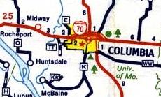
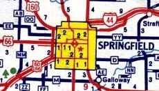
The 1959 insets were of several sizes, but in most cases, the text was larger than for the 1958 insets. In some cases, the scope of the inset map was reduced so that the remaining features could be shown more clearly. New in 1959 was a separate inset map for Carthage, which had previously been shown in a combined Joplin-Carthage map. In most cities where "city routes" had been shown in 1958, the term "business routes" was used instead in 1959.
On each page with an inset map, I have written a description of the numbered routes shown on the inset map. I've done this for all inset maps, including the larger ones. I had to use manual color correction for the insets because the automatic color correction in my image editing program produced odd results. So the insets may look a little yellower and duller than the images from the front of the map.
The following cities had inset maps on the 1959 map (fair use excerpts):
Denver, Colorado
E-mail: Please see the Contact Information page.