Early official maps of California highways are rare, and even later maps can be difficult to find. Thus it was an exciting find to be able to get a 1936 official highway map. The map is similar in format to later official maps of the 1950s and early 1960s, and it's all hand-drawn. One side is in color, with color-coding for different road quality levels (as shown in the legend).
The front of the map also included insets for the Los Angeles region and the San Francisco Bay Area. Those insets were also in color.
The rear of the map showed detailed maps for several major California cities. Also on that side of the sheet was a map of U.S. highways in the western states.
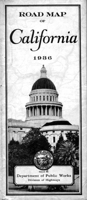
The outside cover wasn't in color; it was a photograph of the state capital in Sacramento. It was actually a part of the rear side of the map.
Back to the front of the map, there was also a list of all the state highway routes. A peculiar aspect of the map is the fact that it shows only US highway designations on the front of the map, except for the Los Angeles and San Francisco insets. On the rear detail maps, only US highway designations were shown as well.
Daniel Faigin has also kindly pointed out that the state highway designations (particularly those shown on the San Francisco and Los Angeles insets) were probably legislative route numbers, which were not reflected in the actual state route numbers that were used to mark the roads.
As a consequence, it can be difficult to trace highway route designations (whether legislative or as marked on the highways) on this map.
From this page, you can access fair use excerpts of the map. Due to its age, the folds are noticeable, but the most of the map itself is in good condition except for a few stains. Most of the scans of the map have been color-corrected to compensate for yellowing of the paper.
Technical Info: These are huge scans, running up to 700-800 KB in some cases. This was necessary in order to show the detail that this map provides. The areas shown by the scans overlap, in part to work around the fact that this map was somewhat fragile, with certain creases that were very tricky to work with without damaging it.
Regional Sections
- San Francisco Bay Area, Sacramento, Lake Tahoe
- Monterey and Salinas, Central Coast, and the middle Central Valley
- Central Coast and the middle and southern Central Valley
- Central Valley and Yosemite National Park
- Eastern Sierras
- Mendocino Coast, the northern end of the Central Valley and Gold Country, plus Lake Tahoe
- Northeastern corner of California
- Northern California
- Northwestern corner of California
- San Bernardino
- Southern California
- East-central California
Regional Insets
Detail Maps of Major Cities
Extras
Denver, Colorado
E-mail: Please see the Contact Information page.