Welcome to the California Road Signs and Sights Gallery! This page lists the most recent additions and changes that have been made. They're categorized by the date they were added.
November 9, 2024
Some additional cleanup, including replacing links to my former Twitter feed with links to my Mastodon feed.October 28, 2024
I have moved from California and am now in Colorado. I will be doing some clean-up work on the site and hope to make it easier to manage.March 8, 2020
Updates have been infrequent in recent years. Site features remain available as a service.December 3, 2017
Yes, there's a lot of backlog. I added a link to a page about the future of this site and related sites (since removed).December 30, 2014
 It's not the best photo, but I have been able to get a view of
the semi-secret California 262 designation appearing on an exit sign along
Interstate 680 in Fremont.
It's not the best photo, but I have been able to get a view of
the semi-secret California 262 designation appearing on an exit sign along
Interstate 680 in Fremont.
Also: in the program to query by city or county, I found a longstanding bug that caused queries with strange capitalization, or in all-caps, to fail. This has been fixed, and you can now use any kind of capitalization you want.
August 16, 2014
Two updates in one week! From a trip to Saratoga, I was able to get a few views of California 9, making its first appearance at the site, as well as a couple of other photos.August 10, 2014
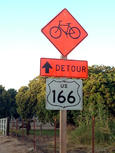 John Rucker shares a great construction sign goof:
US 166 for California 166 in Santa Barbara County near Santa Maria.
Thanks, John! I've also included a few sign shots that I took earlier
this year in this update, most from Silicon Valley. I also made
minor changes to the text on this page to resolve anachronisms that
crept in over time, and to fix a broken link
to the colophon that I added
earlier in 2014 with the site redesign.
John Rucker shares a great construction sign goof:
US 166 for California 166 in Santa Barbara County near Santa Maria.
Thanks, John! I've also included a few sign shots that I took earlier
this year in this update, most from Silicon Valley. I also made
minor changes to the text on this page to resolve anachronisms that
crept in over time, and to fix a broken link
to the colophon that I added
earlier in 2014 with the site redesign.
- US 166 for California 166 in Santa Barbara County near Santa Maria (2013)
- Advance sign for California 87 on US 101 south in San Jose
- Detour sign for Interstate 80 in downtown San Francisco
- California 237 guide sign at Middlefield Road in Mountain View
- Sign for lane positions to turn onto California 237 from Middlefield Road in Mountain View
With this update, I discovered that some of the scripts that I use for updating the site are not functioning correctly, apparently due to the use of a newer version of Perl. I am still able to update small batches of photos, but I will also need to fix the problem in the longer term.
March 30, 2014
New site design! After more than five years with the same design, the site began to look dated. The new design is an evolution from the 2008 version. The biggest change is the use of Google Fonts for the pages. See the colophon for more details about the fonts. For those of you interested in radio, I also recovered articles about my radios from blogging sites that I had used but which either shut down or had other problems.May 12, 2013
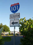 An "Interstate 101" goof appeared at a major Palo Alto intersection
this month, even getting written up in the San Jose Mercury News.
In addition to a couple of photos of that goof, there are a couple of
photos of the western endpoint of Interstate 80 in San Francisco, something
that's very difficult to photograph and something I managed to do only
from the back seat of a cab.
An "Interstate 101" goof appeared at a major Palo Alto intersection
this month, even getting written up in the San Jose Mercury News.
In addition to a couple of photos of that goof, there are a couple of
photos of the western endpoint of Interstate 80 in San Francisco, something
that's very difficult to photograph and something I managed to do only
from the back seat of a cab.
January 27, 2013
 In December 2012, I had foot surgery and was temporarily on crutches.
Since fellow AC Transit patrons were kind enough to allow me to sit
in the front seat of the coach bus on our commuting route, I was able to
try to get photos of the eastern span of the Bay Bridge as it was then.
The span will be replaced by a new span under construction. Lighting
conditions were a bit difficult, but, aside from lacking a bit of
detail, the mobile phone camera seemed to do all right.
In December 2012, I had foot surgery and was temporarily on crutches.
Since fellow AC Transit patrons were kind enough to allow me to sit
in the front seat of the coach bus on our commuting route, I was able to
try to get photos of the eastern span of the Bay Bridge as it was then.
The span will be replaced by a new span under construction. Lighting
conditions were a bit difficult, but, aside from lacking a bit of
detail, the mobile phone camera seemed to do all right.
- Approaching the sharp temporary curve on the east span of the San Francisco-Oakland Bay Bridge (2012)
- Eastern approach to the east span of the San Francisco-Oakland Bay Bridge (2012)
- The temporary S-curve at the Treasure Island exit from the San Francisco-Oakland Bay Bridge westbound (2012)
- The west span of the San Francisco-Oakland Bay Bridge (2012)
- Warnings for the S-curve on the San Francisco-Oakland Bay Bridge (2012)
- San Francisco exits from the San Francisco-Oakland Bay Bridge
- San Francisco city and county line at the east span of the San Francisco-Oakland Bay Bridge (2012)
- Small advance exit sign for Treasure Island on the San Francisco-Oakland Bay Bridge (2012)
- The tunnel at Yerba Buena Island connecting the two spans of the San Francisco-Oakland Bay Bridge (2012)
January 2, 2013
I removed the link to my Tumblr page, which I am no longer maintaining. Subsequently, Posterous shut down, and I ceased maintaining a site on Blogger as well (it still exists but I am not updating it).May 28, 2012
I added a variety of photos this time from San Francisco and the East Bay, most taken with the camera in my Galaxy Nexus mobile phone. Most of the mobile phone photos are of reasonably good quality, and it's more convenient than carrying a dedicated camera around. The photos were all taken in 2012.- A mixture of fonts on a warning sign at the University of California
- The Lefty O'Doul Bridge in San Francisco
- Streetcar transit signal at West Portal in San Francisco
- Orange directional and parking sign in San Francisco
- Cherries as a symbol of San Leandro
- Old-style button-reflector stop sign at an Oakland grocery store
- Tsunami evacuation route marker in San Francisco
December 3, 2011
Added scans from the 1961 official highway map, this time in a size and shape typical of maps that accompanied the state highway department's annual reports. Also took the opportunity to clean up links on the main index page and the map index pages, making minor editing corrections as well where needed. Also added links to my blogs (new as of 2011) and Twitter feed.March 4, 2011
Removed the link to AboutVia, which had been a dead link for quite some time. I also removed the link to the misc.transport.road FAQ.January 19, 2011
 A big thank-you goes out to Chris Cargill, a native and
former resident of Sonora, who explained the story of the traffic
signal with two apparently-identical green lights in his hometown.
That was one of the first photos
that I put on the California site. It's amazing to be contacted
years later by someone who knows the story behind the oddly
configured signal. Now I'll need to retrieve the photo and re-scan it
to a larger size!
A big thank-you goes out to Chris Cargill, a native and
former resident of Sonora, who explained the story of the traffic
signal with two apparently-identical green lights in his hometown.
That was one of the first photos
that I put on the California site. It's amazing to be contacted
years later by someone who knows the story behind the oddly
configured signal. Now I'll need to retrieve the photo and re-scan it
to a larger size!
October 17, 2010
Long overdue, a link has been added to Eric Fischer's Walking SF site, which is rich in photos, maps, and historic documents about Bay Area freeways and transit. Also updated, yet again, the page about the 12th Street dam and viaduct, finally undergoing demolition and reconstruction in 2010, seven years after the project was approved by Oakland voters.- Hand-lettered freeway-style signs on 12th Street in Oakland (revised in 2010)
Also of interest is this blog documenting the project: Oakland 12th Street Project, by local artist Erik Niemann.
July 3, 2010
The temporary terminal, used mostly for commuter bus lines, will replace the 1930s-era Transbay Terminal while it is torn down and rebuilt as a multi-modal transit center.
Also: based on an article in the Oakland Heritage Alliance News, I added information about the 12th Street dam and viaduct in downtown Oakland. It was slated for imminent removal and reconstruction in 2003 when I first posted the page; construction did not begin until 2010.
- Hand-lettered freeway-style signs on 12th Street in Oakland (revised in 2010)
June 19, 2010
Added a link to Cal Traffic Signs (caltrafficsigns.com). (H/T to Daniel Faigin, who spread the word about the site.) My own preference is to photograph signs in their settings as installed, but that's obviously not possible for old and historic signs. There are many such signs at caltrafficsigns.com. I think that fans of signs with button reflectors will especially enjoy it.May 31, 2010
Removed links to the photo-count pages. Certain other sites like to boast of their photo counts. I don't want to participate in that boasting, because I think it doesn't mean anything, especially when you can't find those other sites' photos easily. The pages are still on the site, so you can find them if you know the URL, but they won't be updated automatically. I am keeping them because they've been useful for diagnosing occasional problems with the data used to index and search my photo pages.December 22, 2009
This update implemented a more flexible architecture in the search program for city and county names for handling two-word and three-word city and county names. As a consequence, search results for those cities and counties should now be much more accurate.December 5, 2009
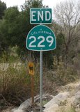 Featuring the obscure California 229, six of whose nine miles are
so narrow that the road doesn't have a center stripe, this set of
29 photos from northern and north-central San Luis Obispo County also
includes California 41, California 46, California 58, and Business
California 1.
Featuring the obscure California 229, six of whose nine miles are
so narrow that the road doesn't have a center stripe, this set of
29 photos from northern and north-central San Luis Obispo County also
includes California 41, California 46, California 58, and Business
California 1.
All photos were taken in late November 2009.
With the addition of an historic marker in Paso Robles, joining an earlier photo from Del Mar, I've also added an index and search category for Historic US 101.
- American Recovery and Reinvestment Act sign in Cambria (2009)
- Overhead arch bridge in Atascadero
- Warning of narrow road on southbound California 229
- California 229 northbound in San Luis Obispo County
- California 229 southbound in San Luis Obispo County
- Southern end of roadway for California 229, showing no center stripe
- Destinations from California 41 at California 229 north of Creston
- Diagrammatic destination sign for the eastern junction of California 41 and 46
- Destinations for California 41 and California 46, including marker symbols, in San Luis Obispo County
- Shandon cutoff for California 41 on eastbound California 46
- California 41 at California 46 in San Luis Obispo County
- Metric and English distances for destinations on eastbound California 46 in Paso Robles
- View of California 46 eastbound from its eastern junction with California 41
- Junction of California 229 at eastbound California 58 northeast of Santa Margarita
- California 58 at the southern end of California 229
- Destinations for California 46 at its western endpoint, including US 101
- End of Business California 1 in Cambria
- End of California 229 in San Luis Obispo County
- End of California 58 near Santa Margarita
- Historic US 101 in Paso Robles
- James Dean Memorial Junction on California 46 at California 41
- Junction of California 41 at California 46 near Shandon
- Junction for South California 229 north of Creston
- North Business California 1 in Cambria
- North and South California 1 in Cambria
- Rattlesnake warning at rest area near Shandon
- South California 41 east of Shandon
- West California 58 and North California 229
- Western end of California 46 at California 1 (no signs)
November 14, 2009
 Removed Nevada metadata on five pages because those cities and counties
were showing up in the search and indexing programs. They shouldn't have
been, but the search and indexing programs don't try to check to see
that a specified city or county is valid. That would be nearly impossible
for cities; much easier for counties. Even so, since I don't make use
of city or county metadata for Nevada, it was even simpler to just remove
the Nevada metadata. Is it a bug fix? Ask the ladybugs (right).
Removed Nevada metadata on five pages because those cities and counties
were showing up in the search and indexing programs. They shouldn't have
been, but the search and indexing programs don't try to check to see
that a specified city or county is valid. That would be nearly impossible
for cities; much easier for counties. Even so, since I don't make use
of city or county metadata for Nevada, it was even simpler to just remove
the Nevada metadata. Is it a bug fix? Ask the ladybugs (right).
Also added a sign from Redwood Regional Park (where my husband also found the swarms of ladybugs):
November 1, 2009
Yolo County gets more representation in this set of photos, taken in August 2009. This set, with 17 photos on 13 pages, also includes nearby areas of Solano County and another photo from Sacramento.- Freeway entrance for California 113 in Davis
- Old-style exit sign with new-style exit number on Interstate 80 at California 113 near Davis
- Series E font for California 113 marker in Davis
- California 128 exit from Interstate 505 in Yolo County
- End of Interstate 680 at Interstate 80 and California 12
- Freeway entrance for Interstate 505 from California 128
- California 113 from westbound Interstate 80 collector/distributor ramp in Solano County near Davis
- California 113 just ahead of its interchange with Interstate 80, showing San Francisco and Sacramento as control cities
- North Interstate 505 in Solano County
- Postmile marker at the eastern endpoint of California 128 east of Winters
- Eastbound destinations, including the easternmost destination, for US 50 in Sacramento
- End of California 128 in Yolo County at county highway E6
- Destinations from Yolo County highway E6 at California 113 in Davis
October 20, 2009
It's the end of the summer photos from the North Bay, wrapping up with 18 photos from Sonoma County.- Creative use of arrow markers for California 128 at US 101 just north of Geyserville
- Destinations for California 128 at Geyserville Avenue in Geyserville
- California 128 single-panel sign almost on the side of a building in Geyserville
- East California 128 from US 101 southbound near Geyserville (advance sign)
- East California 128 from US 101 southbound near Geyserville (at exit)
- California 128 in Geyserville
- Odd Helvetica-like font for California 128 marker in Geyserville
- Postmile marker for California 128 just north of Geyserville
- US 101 freeway sign and California 128 marker in Geyserville
- California 12 marker, mounted on signal mast, in Santa Rosa
- California 12 with oddly placed arrow marker in Santa Rosa
- California 12 in Sonoma
- Destinations for eastbound California 12 in Sonoma
- East and west California 128 in Geyserville
- Directions to US 101 freeway in Healdsburg
- Button reflectors on directional sign at the California 128 freeway entrance to US 101 in Geyserville
- Numerous regulations on park sign in downtown Sonoma
- Mismatched sizes for reassurance markers on US 101 near Cloverdale
October 5, 2009
Fourth in the soon-to-end series of summer photos from the North Bay, this set features more photos from Mendocino County.- Junction sign assembly with arrows for the California 128-253 intersection south of Boonville
- Advance sign for California 253 on eastbound California 128 near Boonville
- Destinations on eastbound California 253 near Boonville, including US 101 as a destination
- Junction of California 175 at US 101 in Hopland
- Dual-purpose junction sign assembly for California 1 and 128 in Mendocino County
- Button reflectors on exit for South Cloverdale Boulevard on US 101 southbound in Cloverdale
- Black-on-yellow directional sign on US 101 in Hopland
- Destinations from Hopland on US 101 southbound
- Russian River bridge on US 101 just south of Hopland
- US 101 as the Redwood Highway south of Hopland
October 4, 2009
Midway through the series of summer photos from the North Bay, this set of 14 photos on 15 pages marks the first appearance of Mendocino County at the site, including the western terminus of California 128.- Destinations, including California 1, on California 128 in Mendocino County
- California 253 at westbound California 128 near Boonville
- California 128 destination sign with partial use of button reflectors
- Single-panel route markers for California 128 at US 101 in Cloverdale
- A not-advised warning on California 128 westbound near Geyserville
- Advance sign for California 253 on westbound California 128 near Boonville
- Destinations within Cloverdale on US 101
- Last exit for Cloverdale from northbound US 101
- Faded blue roadside-business signs on US 101 in Cloverdale
- Destinations from the western endpoint of California 128
- End of California 128 in Mendocino County
- Junction of California 1 at California 128's western endpoint in Mendocino County
- California 128 exits westbound from US 101 in Cloverdale (advance sign)
- California 128 exits westbound from US 101 in Cloverdale (at exit)
September 28, 2009
Second in the series of photos from the North Bay, this set of 13 photos features US 101 in Sonoma County from Petaluma to Geyserville.- California 12 exit from US 101 (advance sign)
- California 12 exit from US 101 in Santa Rosa (at exit)
- Exit for East California 116 from US 101 in Petaluma (advance sign)
- Complete sign gantry at the US 101-California 12 interchange in Santa Rosa
- Destinations within Healdsburg on US 101 northbound
- Exit for Petaluma Boulevard South from US 101 in Petaluma
- Destinations for US 101 northbound in Santa Rosa
- Exit for East California 116 from US 101 in Petaluma (at exit)
- Trailblazer exit to California 128 from US 101 in Geyserville (advance sign)
- Trailblazer exit to California 128 from US 101 in Geyserville (at exit)
- Through-traffic sign for Healdsburg on US 101 in Santa Rosa
- Exit for West California 116 in Cotati (advance sign)
- Exit for West California 116 in Cotati (at exit)
September 27, 2009
Beginning a new series, featuring areas in the northern parts of the San Francisco Bay Area, this set focuses on 11 photos along US 101 in Marin County, up to the Sonoma County line, taken in July 2009.- Button reflectors on exit sign for Atherton Avenue on US 101 in Novato
- California 37 exit from US 101 in Marin County (advance sign)
- End of freeway on US 101
- Warning sign for end of freeway on US 101 in Marin County
- End of Interstate 580 in San Rafael
- Button reflectors on exit sign for Marinwood from US 101
- Route 101 Business in Novato
- Sonoma County line on US 101 northbound
- Old and new style exit signs at the California 37-US 101 interchange in Novato
- Destinations on US 101 northbound in Marin County
- Destinations within Novato on US 101 northbound
I also discovered that two earlier photos from Petaluma had been miscategorized as being in Marin County, rather than Sonoma County. This error only affected search and indexing results, but it has now, finally, been corrected in this update.
August 16, 2009
Finishing up the series of photos from my July 2009 trip to Nevada City, this set includes photos in and near Nevada City, Sacramento, and along Interstate 680. There's a total of 18 photos on 16 pages.- Complex parking sign in Davis
- All upper-case exit sign on southbound Interstate 680 in Solano County
- Destination and reassurance signs with button reflectors on Interstate 680 on the Benicia-Martinez Bridge
- One-way sign in Nevada City, possibly using the rare Series F sign font
- The Nevada County Courthouse in Nevada City
- The newer Highway 49 bridge over the South Yuba River
- Decorative details on the first Highway 49 bridge over the South Yuba River
- The first Highway 49 bridge over the South Yuba River
- Lighted pedestrian warning sign at Neasham Circle and Capitol Mall in Sacramento
- Pedestrian and rail-crossing warning sign at Neasham Circle and Capitol Mall in Sacramento
- California 4 interchange with Interstate 680 (advance sign)
- California 4 interchange with Interstate 680 (at exit)
- Interstate 780 from southbound Interstate 680 (advance sign)
- Interstate 780 from southbound Interstate 680 (at exit)
- U-turn signal in downtown Sacramento, all three phases
- U-turn signal in downtown Sacramento with U-turn arrow
July 28, 2009
This time, it's the final set of photos from my May 2009 trip (23 photos on 20 pages), featuring Solano County, including signs for Interstates 680 and 780, and lots of button reflectors. All the updates together from the May 2009 trip added 65 new photos on 60 pages (not counting the two I-505 photos from the July trip).- Caltrans funding for road work on California 12 east of Suisun City
- California 12 eastbound exit from Interstate 80 (advance sign)
- California 12 eastbound exit from Interstate 80 (at exit lanes)
- California 12 safety corridor east of Suisun City
- California 12 trailblazer for an exit from eastbound Interstate 80
- California 37 exit from eastbound Interstate 80 in Vallejo (advance sign)
- California 37 exit from eastbound Interstate 80 in Vallejo (at exit)
- California 37 exit from eastbound Interstate 80 in Vallejo (reminder sign)
- Exit sign for Central Vallejo on Interstate 80
- Destination sign on California 12 eastbound in Suisun City
- Reassurance marker for California 12 near Suisun City
- End of a freeway section on California 12 in Fairfield and Suisun City
- California 29 exit at Exit 29 from Interstate 80 in Vallejo
- Interstate 680 from eastbound Interstate 80 in Cordelia
- Interstate 680 exit from eastbound Interstate 80 (advance signs with and without button reflectors)
- Interstate 780 exit from Interstate 80 in Vallejo (advance sign)
- Interstate 780 exit from Interstate 80 in Vallejo (at exit, backlighted)
- California 12 eastbound exit from Interstate 80 (at exit)
- Exit signs from Interstate 80 for city streets in Vallejo
I also updated the Zampa Bridge section of the site with an additional photo, showing a view of the old and new bridges across the Carquinez Strait as they appear in 2009:
July 21, 2009
I'm mixing it up this time with photos from two trips. The first set comprises 13 more photos from a May 2009 trip along Interstate 80.- California 4 at Interstate 80 (exit sign close-up)
- California 4 at Interstate 80 near Hercules (advance exit sign at Pinole Valley Road)
- California 4 at Interstate 80 near Hercules (advance exit sign)
- New-style exit signs on Interstate 80 in Rodeo
- Destinations for Interstate 80 approaching California 4 in Hercules
- Button reflectors on blue services sign on Interstate 80 in Hercules
- Toll crossing sign and blue services sign on Interstate 80 in Crockett
- Retrofitted exit number for exit on Interstate 80 in Crockett
- Oddly tiny lettering on destination sign for Interstate 80 eastbound in Richmond
- California 4 at Interstate 80 near Hercules (exit from eastbound I-80)
- Destination sign including California 4 on Interstate 80 eastbound in Pinole
- Unusual exit-number style for exit sign on Interstate 80 eastbound in Crockett
- Carpool exit for the Richmond Parkway on Interstate 80 in Richmond
The second set is from a July trip to Sacramento (the trip during which my new car was rear-ended). Here are a couple for Interstate 505's interchange with Interstate 80:
June 28, 2009
Yet more signs from Interstates 80 and 580 in Oakland, Emeryville, Berkeley, and Albany -- 13 signs on 11 pages.- Destinations for Interstate 80 in Albany
- Emeryville exit and advance exit sign for California 13 on Interstate 80 and 580
- California 13 exit from Interstate 80/580 in Berkeley
- University Avenue exit from Interstate 80/580 in Berkeley
- Split of Interstates 80 and 580 in Albany
- Berkeley destinations on Interstate 80/580
- Split of Interstates 80 and 580 (advance sign assembly in Berkeley [close-ups])
- Split of Interstates 80 and 580 (advance sign assembly in Berkeley)
- Interstate 580 approaching the MacArthur Maze in Oakland from the southeast
- Westbound Interstate 580 and eastbound Interstate 80 in the MacArthur Maze in Oakland
- Westbound and eastbound directions for the Interstate 80/580 concurrence in Berkeley
June 14, 2009
Two updates in one month! This one is a set of photos taken in May on freeways in Oakland, showing many signs with button reflectors still in place.- California 13 northbound at California 24, with Caldecott Tunnel backup
- Button reflector close-up on California 13 at California 24 in Oakland
- College Avenue exit from California 24 in Oakland
- Destinations for California 24 westbound in Oakland
- Telegraph Avenue exit and advance sign for the Interstate 580 interchange on California 24 in Oakland
- California 24/Interstate 580/Interstate 980 interchange in Oakland
- Advance sign for the Interstate 580 interchange on westbound California 24 in Oakland (close-up)
- Advance sign for the Interstate 580 interchange on westbound California 24 in Oakland
- California 24 transitions to Interstate 980 at Interstate 580 in Oakland
- Left ramp from California 13 to California 24 in Oakland
- College Avenue exit sign and Telegraph Avenue advance sign on California 24 in Oakland
- Variable message sign on California 24 in Oakland
- Historic route sign on Interstate 580 for Interstate 80 in Oakland
- Ramps for eastbound and westbound Interstate 580 in the so-called 'mini maze' in Oakland
- Interstate 980, trailblazing to Interstate 880 in Oakland (close-up)
- A 'ramp' sign rather than an 'exit' sign for California 24 at California 13 in Oakland
June 2, 2009
Another historic map joins the collection: the 1936 California official highway map. Included are a list of all state routes in 1936 and a map of US highways in the western states.September 9, 2008
Added nine photos, taken in July 2008, of the MacArthur Maze and the "Mini-Maze" of the Interstate 980-California 24 interchange from Interstate 580 in Oakland.- Complex advance sign for Interstate 580 and California 24 in Oakland
- Interstate 980 at Interstate 580 and California 24 in Oakland
- East end of the MacArthur Maze in Oakland
- Patched-up Interstate 980 and 880 sign on Interstate 580 in Oakland
- California 24 from Interstate 580 in Oakland, with advance sign for Interstates 880 and 980
- Interstate 880 at Interstate 80 in Oakland
- Approaching the Interstate 80-580 interchange in Oakland
- Entering the heart of the MacArthur Maze on Interstate 80 in Oakland
- Interstate 980 from Interstate 580 and California 24 in Oakland
August 8, 2008
Rearchitected the entire Signs & Sights family of sites. All URLs changed and are now shorter. The easy way to convert any given URL: remove /road/sign from the old URL to get the new URL.June 29, 2008
Added links to the new and improved New Mexico Signs & Sights Gallery.May 11, 2008
Everyone's favorite new font (this depends on your definition of "everyone"), Clearview, shows up on another new signal installation in Oakland!April 12, 2008
A sign replacement project started this month on Interstate 580 in Oakland and San Leandro. Not just the old button-reflector signs were replaced. New mounting posts were installed as well, affording the opportunity to see both old signs and new signs together for a short period of time. In this set, I also tried to get a better close-up of the Interstate 238 exit sign from Interstate 580, replete with button reflectors that are likely to be replaced soon.- New and old exit signs for 150th Avenue at Interstate 580 in San Leandro (2008)
- Interstate 580 designation as the MacArthur Freeway
- Freeway view of Interstate 580 north of Hayward
- New and old exit signs for Keller Avenue at Interstate 580 in Oakland (2008)
- Exit sign for Interstates 238 and 880 from Interstate 580 near Hayward (2008 close-up)
I also revised the page with the 2007 photo of the Interstate 238 (and California 238) exit sign to cross-link the 2007 photo with the newer 2008 photo.
Follow-up, April 13, 2008
From subsequent discussions in misc.transport.road (where I posted a notice of this update), I learned that the new supporting structure of the I-580 sign gantries is called a monotube. So I have revised the new pages accordingly. I also had omitted a custom HTML title tag from the new pages; this "silent update" fixed that problem. I also changed the description for two other pages related to Interstate 238. Both of those descriptions had said "Interstate 238 close-up" but they were actually quite different photos. The two pages affected:
March 1, 2008
I've added another historical document about the Bay Bridge. This one also includes the Golden Gate Bridge. It's a little 1939 guide titled How to Use the New Bridges, distributed by Standard Oil of California.I also fixed some minor bugs in the search programs, and fixed a rather important bug that caused results from Los Angeles County to be omitted. Unfortunately, I only have one photo from that county right now, but I'm hoping at some point in the future to have more.
December 27, 2007
Here are more big green signs, and some big orange signs, too, from a November 2007 across the San Francisco-Oakland Bay Bridge, as well as some freeway signs in Oakland and a variety of other road sights. This update added 17 new photos.- Sign prohibiting flammable materials on the San Francisco-Oakland Bay Bridge
- One of the suspension towers of the San Francisco-Oakland Bay Bridge
- California 24 and Interstate 980 at Interstate 580 in Oakland
- East and west exits for Cesar Chavez Street from US 101 in San Francisco
- Exits for US 101 from Interstate 80 in San Francisco (advance sign)
- The last westbound exits on Interstate 80 in San Francisco
- Big orange sign and big green sign for westbound exits from Interstate 80 in San Francisco, along with one of the towers of the Bay Bridge (2007)
- Big orange exit sign for Fremont and Folsom Streets from Interstate 80 in San Francisco (2007)
- Interstate 280 and other destinations on southbound US 101 in San Francisco
- Interstate 980 and California 24 exit from Interstate 580 in Oakland (advance sign)
- Fifth Street exit from Interstate 80 in San Francisco
- Advance exit sign before the MacArthur Maze on Interstate 580 in Oakland
- Entrance to the MacArthur Maze on Interstate 580 in Oakland
- Trailblazer sign for Interstate 880 via Interstate 980 in Oakland
- Backlighted big green sign on Interstate 80 on the San Francisco-Oakland Bay Bridge (2007)
- Big orange signs for westbound traffic on the San Francisco-Oakland Bay Bridge (2007)
- Western endpoint of Interstate 80 in San Francisco
December 23, 2007
There are plenty of big green signs, plus a few others, for the holiday of your choice from my November 2007 trip to San Diego. There are 64 photos in this update, including both ends of California 75 and California 282.- Approaching eastern endpoint of California 905
- Advance sign for the California 163 exit from Interstate 5 in downtown San Diego
- Close-up of button reflectors on exit sign for California 163 from Interstate 5 in downtown San Diego
- California 163 at Interstate 5 with advance sign for California 94 in downtown San Diego
- California 163, northbound and southbound, at eastbound Interstate 8 in San Diego
- Westbound Interstate 8 from northbound California 163 in San Diego
- California 163, northbound and southbound, at eastbound Interstate 8 in San Diego (advance sign)
- Interstate 8, westbound and eastbound, at northbound California 163 in San Diego
- Retrofitting an exit number on a California 163 advance exit sign on Interstate 5 in San Diego
- End of Ardath Road at two freeways in San Diego
- Advance exit sign for California 54 on southbound Interstate 5 in National City
- California 54 at southbound Interstate 5 south of San Diego
- California 75 in Imperial Beach
- End of California 282 at California 75 in Coronado
- California 75 exit from Interstate 5 in San Diego County
- California 75 marker with small digits in Coronado
- California 75 destination sign to San Diego in Coronado
- Destination sign including California 76 on Interstate 5 in Oceanside
- Downtown Oceanside exits from northbound Interstate 5, including California 76
- California 76 marked as a cross street in Oceanside
- California 78 from northbound Interstate 5 in Oceanside
- California 78 from southbound Interstate 5 in Oceanside (advance sign)
- California 78 from southbound Interstate 5 in Oceanside
- Special advance sign for California 78 on Interstate 5 in Oceanside
- Interstate 805 as destination on eastbound California 905 in San Diego County
- Pictographic warning sign for illegal immigrants on California 905 in San Diego County
- California 76 exit from Interstate 5 in Oceanside at the western endpoint of California 76
- Welcome sign for Del Mar
- Trailblazer for Interstate 8 at Hotel Circle Drive in San Diego
- End of California 905 in San Diego County
- Foldout destination sign on California 282 in Coronado
- Button reflectors for westbound and eastbound Interstate 8 at northbound California 163 in San Diego
- Highway 101 as a street name in Del Mar
- San Diego neighborhood district sign for Hillcrest
- Historic US 101 in Del Mar
- Interstate 5 approaching California 54 in National City
- California 52 at Interstate 5 near San Diego's La Jolla district
- Interstate 8 as seen from Presidio Park in San Diego
- California 163 on destination sign along Interstate 5 in San Diego
- Advance sign for California 75 on northbound Interstate 5 in southern San Diego County
- Destination sign for California 905 on southbound Interstate 5
- Destination sign at Interstate 805 exit ramp from California 905
- Rosecrans Street at Interstate 5 in San Diego
- California 94 advance sign on Interstate 5 approaching downtown San Diego
- California 905 at Interstate 5 in San Diego County
- Interstate 805 exit from California 905 in San Diego County
- Button reflectors for the Hotel Circle exit on Interstate 8 in San Diego
- Interstate 5, Interstate 8, and former California 209 at Hotel Circle in San Diego
- Interstate 5, Interstate 8, and former California 209 in San Diego
- Interstate 8 from northbound Interstate 5 in San Diego
- Bridge-mounted advance sign for California 78 on Interstate 5 in Oceanside
- Pictographic sign indicating dangerous cliffs in La Jolla (San Diego)
- No games of sport in La Jolla (San Diego)
- Exit for California 15 from northbound Interstate 5 in San Diego (advance sign)
- Exit for California 15 from northbound Interstate 5 in San Diego
- Directions for California 75 from the endpoint of California 282 in Coronado
- Exits for northbound and southbound Interstate 805 from California 905 in San Diego County
- Button reflectors on destination sign near Oceanside
- Traffic safety sign on California 76 near Oceanside
- San Diego city limits on the Coronado Bridge
- Texas-style marker assembly for California 75 and 282 in Coronado
- Northeast end of California 75 at Interstate 5 in San Diego
- Trailblazers to Interstates 5 and 8 in San Diego
- California 282 in Coronado
September 7, 2007
Added a couple of photos from California 61 in Alameda, including one marker assembly that may -- or may not -- be at the end of the route.September 4, 2007
Added 26 photos in San Mateo and Alameda County, mostly on California 92 and the San Mateo Bridge. There are many examples both of the older-style button-reflector freeway signs, still in use in Alameda County, and the newer-style reflective signs with exit numbers, which now predominate in San Mateo County.- US 101 at eastbound California 92 in San Mateo
- Advance signs for US 101 on westbound California 92 in San Mateo
- Westbound California 92 at US 101 in San Mateo
- Typical example of exit numbers on westbound California 92 in San Mateo
- Destinations on California 92 in San Mateo
- California 82 advance exit sign on eastbound California 92 in San Mateo
- California 82 exit from eastbound California 92 in San Mateo
- California 82 at eastbound California 92 in San Mateo
- California 92 as the J. Arthur Younger Freeway in San Mateo County
- Destinations on westbound California 92 in San Mateo approaching US 101
- Advance signs for Interstate 280 on westbound California 92 in San Mateo
- California 92 joins Interstate 280 in San Mateo
- Freeway entrance for Interstate 280 from Sand Hill Road in San Mateo County
- Exit sign for California 84 from Interstate 280 (advance sign)
- Exit sign gantry for California 92 from southbound Interstate 880 in Hayward (first of two signs)
- Exit sign gantry for California 92 from southbound Interstate 880 in Hayward (second of two signs)
- California 92 on the way to the San Mateo Bridge in Hayward
- Destinations on westbound California 92 just east of the San Mateo Bridge
- Variable message signs for FastTrak lanes at the San Mateo Bridge toolbooth
- Variable message signs for FastTrak lanes approaching the San Mateo Bridge toolbooth
- Elevated section of the San Mateo Bridge, from the eastern approach
- Destination sign for California 92 westbound in the collector/distributor lanes of Interstate 880
- Advance signs for Interstate 880 on eastbound California 92 in Hayward
- Advance sign for Interstate 880 plus warning for the end of the freeway on California 92 eastbound in Hayward
- Curved arrow for exit sign from California 92 to Interstate 880 in Hayward
- Variable message sign along Interstate 880 in Hayward for the Labor Day 2007 Bay Bridge closure
May 9, 2007
This time, it's a series of windshield shots taken in April 2007 on US 101 in San Jose, Gilroy, San Benito County, and Monterey County. Even though they're windshield shots, most of them came out well, and many of them show the classic button-reflector exit signs that are gradually being replaced by Caltrans. For signal fans, there's also a photo of a single-arrow signal assembly in Paso Robles.- Exit for California 129 from US 101 in San Benito County (advance sign)
- Exit for California 129 from US 101 in San Benito County
- Exit gantry from California 156 on US 101 west of San Juan Bautista
- California 156 west from US 101 southbound in Monterey County
- Single-arrow green signals on California 46 in Paso Robles
- Exit for California 82 from US 101 in San Jose (advance sign)
- Exit for California 82 from US 101 in San Jose
- Carpool exit and regular exit for California 85 from US 101 in San Jose (advance sign)
- Advance exit sign gantry for California 85 at US 101 northbound in San Jose
- Exit sign gantry for California 85 at US 101 northbound in San Jose
- Advisory sign for Castroville on US 101 southbound in Monterey County
- Button reflectors for Interstates 280 and 680 from US 101 in San Jose
- Button reflectors on advance exit sign for Interstates 280 and 680 from US 101 in San Jose
- Sign gantry for US 101 from Interstate 880 southbound in San Jose
- Advance sign for California 25 on US 101 south of Gilroy
- Mileage sign with button reflectors on US 101 northbound ahead of Interstates 280 and 680 in San Jose
- Button reflectors for US 101, Interstate 280, and Interstate 680 on a San Jose sign gantry
April 16, 2007
Here's more Clearview in northern California, this time at a Salinas shopping center.April 5, 2007
Added ten photos from late February, featuring big guide signs with button reflectors and Interstate 238.- Advance exit sign for California 13 on Interstate 580 in Oakland (close-up)
- Advance exit sign for California 13 on Interstate 580 in Oakland (showing Interstate 580 as well)
- South end of California 13 at Interstate 580 in Oakland
- California 185 in San Leandro
- Traffic backup on Interstate 238 at the California 185 exit south of San Leandro
- California 185 exit from Interstate 238 south of San Leandro
- Interstate 580 approaching the Interstate 238 and California 238 interchange north of Hayward
- California 92 at Interstate 880 in Hayward
- Mileage sign for Interstates 238 and 580 on northbound Interstate 880
- Advance sign for Hesperian Boulevard entrance to Interstate 238 in San Leandro
March 4, 2007
Added a section to the web site featuring historic maps and brochures of the San Francisco-Oakland Bay Bridge. Included are maps of the Bay Area before the bridge was built, and a 1927 planning map showing proposed routes, none of which were built!February 17, 2007
Clearview, the sign font that is replacing the FHWA series of fonts in many states, has shown up on a couple of new street signs in Oakland. This is the first use of Clearview that I've observed in northern California.January 20, 2007
The "version 7" page of links has been removed from the site, in hopes of making maintenance less burdensome and allowing me more time to work on content.December 16, 2006
A new section has been added, featuring fair use excerpts from the official California highway map for 1956. It's interesting to compare this map to the official California highway map for 1966, excerpts of which were added to this site in August 2006.December 5, 2006
From a Thanksgiving weekend trip, here are 16 photos (plus one close-up) from San Luis Obispo, Monterey, and Santa Clara counties.- Trailblazer to California 183 from US 101 in Salinas
- Advance sign for Interstates 680 and 280 along with California 130 on US 101 in San Jose
- Sea otter in Morro Bay
- Morro Rock overlooking the Embarcadero in Morro Bay
- Morro Rock, seen from the south end of Morro Bay
- Morro Rock in Morro Bay
- Morro Rock, overlooking boats in Morro Bay
- Advance exit sign for California 146 on US 101 in Soledad
- Exit sign for California 146 from US 101 in Soledad (northbound)
- California 198 exit from US 101 in San Lucas (northbound)
- No cutout shield for US 101 at a freeway entrance in Salinas
- Big arrows for US 101 and California 1 trailblazers in downtown San Luis Obispo (leaving city parking garage)
- Big arrows for US 101 and California 1 trailblazers in downtown San Luis Obispo (on Pacific Street)
- California 198 exit from US 101 in San Lucas (southbound)
- Exit sign for California 146 from US 101 in Soledad (southbound)
- Sign gantry on southbound US 101 in Salinas
Updated Page
The information on this page about a trailblazer sign in downtown San Luis Obispo was updated to reflect the fact that these signs have been replaced.November 19, 2006
With the opening of the new Pier 14 in San Francisco earlier this fall, I was able to get some nice perspectives of the Bay Bridge and the Ferry Building in these photos, taken November 1.- San Francisco Bay Bridge, as seen from Pier 14 in San Francisco
- A suspension tower of the San Francisco Bay Bridge, as seen from Pier 14 in San Francisco
- Coit Tower in San Francisco
- San Francisco Ferry Building with Coit Tower in the background
- San Francisco Ferry Building, viewed from Pier 14
- Streetcar signal in San Francisco at the Embarcadero
November 13, 2006
Here are four more contributions from Rich Piehl's July trip in the Sierras and Sacramento. Thanks again, Rich!October 1, 2006
I removed all the direct e-mail links from the pages that had those links. This is an attempt to reduce a particularly difficult type of spam that has begun showing up at my e-mail provider. A new e-mail address is provided on a separate Contact Information page.August 31, 2006
It's the Flashing Yellow Edition, with a rare flashing yellow arrow for a left-turn signal!August 28, 2006
A new section has been added, featuring fair use excerpts from the official California highway map for 1966.August 26, 2006
Adding a new route to the roster of highways shown at this site, I've added a couple of photos from Alameda.August 25, 2006
Rich Piehl contributed a couple of photos from Mono County, including one of US 6. Thanks, Rich!Also, now that there are a few contributions, I have added an index of contributors.
August 20, 2006
Thanks to Ralph Herman for this photo of a button-reflector freeway entrance sign at Interstate 5 in Burbank!August 6, 2006
The last two photos made with film, one of a slightly odd freeway entrance in Concord, and the other showing a hazy view of the Bay Bridge that was softened nicely by the use of film. From this point forward, it's all digital!August 1, 2006
Eight more photos using the new camera, this time in Oakland and on California 24 in Contra Costa County.- Mileage sign on California 24 approaching the Caldecott Tunnel
- Verbose pedestrian warning sign in Oakland
- Button reflectors on directional sign at California 13 freeway entrance in Oakland
- Button reflectors at Interstate 580 freeway entrance in Oakland
- San Francisco flashing and double yellow signals (two photos)
- Smaller numerals on a freeway entrance sign on California 13 in Oakland
- Advance sign for use of the right tunnel on California 24 approaching California 13
July 24, 2006
Added 11 new photos from San Francisco and Emeryville, taken with my new digital camera.- Burned-out LEDs on San Francisco traffic signal
- The Embarcadero along the San Francisco waterfront
- Bay Bridge morning shadow over the Embarcadero in San Francisco
- The Embarcadero between the Ferry Building and the Bay Bridge in San Francisco
- The Embarcadero and the San Francisco skyline
- A finger of fog in San Francisco Bay
- Big green sign for I-80 and I-580 freeway entrance in Emeryville
- Opposite directions on I-80 and I-580 freeway entrance in Emeryville
- San Francisco skyline as seen from the Bay Bridge
- An extra F for spelling in San Francisco
- Is bad spelling a crime in San Francisco?
July 10, 2006
Added five photos from Oakland and San Diego.May 25, 2006
A design facelift for the entire site! The biggest changes are at the Missouri, California, and US Highways Signs and Sights Galleries, where the top-level index page has been replaced by a search page, enabling you to quickly find photos for specific routes, types of routes, or categories of photos. You can also search for photos relating to specific cities or counties.Other than the new search pages, the most notable changes seen by most users will be the new fonts used across the entire site. The new design should also look a little bit better with Internet Explorer 6 than the old design.
March 29, 2006
Added an index by photo category to the other category indexes.January 16, 2006
Added five photos from a November 2005 trip to San Diego. Especially notable are the one-way signs with button reflectors!December 30, 2005
Added a page listing all California photos at this site, alphabetized by the descriptive text in the link. Anchors are included for each letter of the alphabet. For example, adding "#U" to the URL will take you directly to the links beginning with the letter U, including photos of US route "cutout" style markers.December 13, 2005
Added anchors within the indexes by category. I hope to make more use of this feature in the future. In the meantime, you can use them to move around more quickly in each of the indexes. For example, when in the Route Index, type "#CA24" after the URL to find the listings for California 24. When in the City Index, type "#Oakland" after the URL to find the listings for Oakland. Be sure to omit any spaces and punctuation marks (examples: US50, BL80, US101, SanFrancisco, SanLuisObispo). In the Route Index, use "BL" for Business Loops and "BR" for Business Routes.December 5, 2005
Added programs that create page and photo counts of the California cities, counties, routes, and route types shown in the California Road Signs and Sights Galleries, as well as counting the categories of photos shown.December 4, 2005
Moved eight pages (with nine photos) into the California gallery from the US Highways Signs and Sights Gallery. I decided to consolidate all the California photos into the California gallery.- US 101 freeway entrance trailblazer in Arroyo Grande (button reflectors)
- California 182 and US 395 in Bridgeport
- Historic US 40 and the Lincoln Highway in Auburn
- Historic US 99 (Red Bluff and Yreka)
- US 101 cutout near San Mateo
- US 395 and California 120 near Mono Lake
- Wide-style marker for US 6 on a mileage sign on California 120 in Mono County
- US 50 at South Lake Tahoe
December 1, 2005
Added a series of 21 photos from the Octavia Boulevard project in San Francisco, which opened to traffic on September 9 and 10, 2005. The photos were by an anonymous contributor on September 24, 2005.August 28, 2005
Added indexes by category. These indexes list pages at all the sign galleries, not just the California gallery. These indexes were made possible by the huge XHTML conversion earlier this year. They are a first step toward a new approach toward managing the galleries that I hope to unveil in the coming months. The new indexes are:August 13, 2005
Added 13 photos from July 2005 in the Paso Robles area and August 2005 in Oakland. Especially notable is an Interstate 880 marker within a California spade outline.- Interstate 880 marker within a California spade outline in Oakland
- Trailblazer with button reflectors for California 13 freeway in Oakland
- Illuminated overhead sign in Oakland
- Uptown Oakland: Fox Theater | I. Magnin building | Paramount Theater
- Directional sign for wineries in San Luis Obispo County near Paso Robles
- End of San Luis Obispo County highway G14
- Trailblazer for San Luis Obispo County highway G14
- California 46 at US 101 in Paso Robles
- West California 46 joins US 101 South in Paso Robles
July 20, 2005
Added 19 new photos, many from November 2004 and July 2005 trips to San Luis Obispo and Santa Barbara and an April 2005 trip to Riverside and Imperial counties.- Prominent bicycle warning sign in Avila Beach
- Business Loop 10 in Indio
- End of California 1 in Santa Barbara County
- Interchange for the end of California 1 at US 101 in Santa Barbara County
- Unusual font on Santa Barbara street signs
- Misspelled street name in Oakland
- Imperial-San Diego county border on Highway S22
- Moreton Bay fig tree, Santa Barbara
- California 86S and 111 in Riverside County
- Orange California 24 sign in Oakland
- Button reflectors on STOP sign at the Orange Empire Railway Museum
- San Diego County call box on Highway S22
- The traffic circle in Borrego Springs
- Mileage sign for US 101 and California 1 in San Luis Obispo
- California 86S in Riverside County
- California 86 and 86S in Riverside County
- US 101 tunnel at the Gaviota Pass in Santa Barbara County
- Non-freeway entrance for US 101 in Santa Barbara County
- US 101 freeway entrance trailblazer in Arroyo Grande (button reflectors)
May 27, 2005
Converted all pages to XHTML 1.1. Added three photos from my archives, taken in 1999 and 2000. Rescanned 27 photos, most from 1999 and 2000, for better quality and, in some cases, larger images. Renamed seven photos for consistency with my current naming scheme.Added Photos
Rescanned Photos
Nine of these have also been renamed, indicated by an asterisk.- Historic streetcar on Church Street in San Francisco
- *Directional sign for California 4 in Angels Camp
- Warning light for heavy traffic on the Embarcadero in San Francisco
- California 270 where it becomes a dirt road outside the ghost town of Bodie
- California 20, 49, and 174 in Grass Valley
- *California 4 and 49 in Angels Camp
- Old-style US 66 sign in Needles (probably not official)
- US 95 in Needles
- End of California 267 in Tahoe Vista
- US 95 along with Interstate 40 near Needles
- Alameda County's version of the California spade
- San Francisco and Los Angeles on US 101 from San Luis Obispo
- *Monterey city sign for California 1 and 68
- *North and South California 1 in Monterey
- Hand-lettered freeway-style signs on 12th Street in Oakland
- *Orange Interstate shields in Berkeley
- *Business US 101 in Petaluma
- *Trailblazers for California 1 and US 101 in San Luis Obispo
- *Trailblazers for freeways in downtown San Francisco
- Trolley warning light for pedestrians, San Francisco
- Trolley crossing warnings in San Jose
- *County route marker in Tuolumne County
- Button reflectors for US 50 at the California 89 intersection
- US 97 turning onto Business Loop 5 in Weed
- A Wells Fargo office in rural Nevada County
Renamed
These photos were not rescanned, just renamed.- Historic California 1 bridge near Big Sur
- Business Routes 20 and 49 in Nevada City
- End of California 41 at Yosemite National Park
- Freeway entrance for California 20 and 49 in Nevada City
- California 20 and 49 freeway in Nevada City
- Freeway entrance for California 24 in Oakland
- Trailblazer for California 13 in Oakland
October 18, 2004
Added photos from my trip to upper northern California in September 2004, including a series of photos from the Sundial Bridge (opened 2004) in Redding, designed by Santiago Calatrava.- Sundial Bridge photos
- Business Loop 5 and California 36 in Red Bluff
- California 3 and California 263 in Yreka
- California and California 263 with I-5 trailblazer in Yreka
- Historic US 99 in Red Bluff (a larger version of the photo that was posted in the US Highways Signs and Sights gallery)
- AAA U-turn sign in Red Bluff
- Mount Shasta as seen from Weed
- US 97 and Business Loop 5 in Weed (also the end of unmarked California 265)
- US 97 exit from Interstate 5 (button reflectors)
- US 97 shield in Weed
- US 97 turning onto Business Loop 5 in Weed
August 15, 2004
Added a series of photos from the Al Zampa Memorial Bridge (opened 2003), the site of the roadfan ("roadgeek") meeting for Northern California on June 26.June 10, 2004
A correction and an update.- Correction: California 20, 49, and 174 junction sign assembly in Nevada City (the link was broken on the main index page)
- Update: Old US 50 designation for Interstate 580 in Oakland. The US 50 shield on the I-580 freeway sign was covered back up late in December 2003.
February 10, 2004
- California 227 near San Luis Obispo
- Trailblazers in San Juan Bautista
- Business 101 near Santa Maria (outline style)
- San Francisco and Los Angeles on US 101 from San Luis Obispo
- Narrow font: California 1 in Pismo Beach
- Uncial font on San Luis Obispo street signs
- Old one-way sign in San Juan Bautista
- San Juan Bautista sights: Mission | El Camino Real | Buggy in a famous movie
- Solvang, a Danish-American community: Scene on California 246 | Another view | Street clock | Tivoli Square | Windmill
- Carnegie library in San Luis Obispo
- Proposed California 77 in Oakland
- Downtown San Francisco in 1988
Earlier Updates
(Not a complete list)
July 17, 2003: Added 43 photos from my May 2003 trip to Lake Tahoe, Mono Lake, and Nevada City. Six more photos from that trip were originally posted at the US Highways Signs & Sights site.
February 1, 2003: Updated information about the US 50 shield along Interstate 580 in Oakland (thanks to Mike Wiley). Also added six more Oakland-area photos: along California 24 near California 13, near Interstate 880, in Chinatown, and along 12th Street near Lake Merritt.
January 21, 2003: Added photos of old US 50 shield, revealed on an Interstate 580 sign in Oakland, and a trace of the old California 17 designation for Interstate 880, also in Oakland.
December 31, 2002: Added photos from Mission Street in downtown San Francisco of non-symbolic pedestrian signals and an extensive set of warning signs at Mission and Fremont Streets.
October 22, 2002: Added 16 photos in and around Interstate 238 in Hayward as well as from Stockton and Sacramento. Also added a link to my page of Yosemite photos. Also updated the status of the "Bekerley" sign at California 13 in Oakland.
Denver, Colorado (formerly Oakland, California)
E-mail: Please see the Contact Information page.